 Filter: Categories of Wisconsin Historical Images
Filter: Subject of Sawmills
Filter: County of Iron
Filter: Categories of Wisconsin Historical Images
Filter: Subject of Sawmills
Filter: County of Iron

| Date: | 09 1891 |
|---|---|
| Description: | Sanborn map of Hurley, featuring the Village of Gile and the Montreal River Lumber Company. |

| Date: | 1898 |
|---|---|
| Description: | Sanborn map of Hurley featuring the Village of Gile. |

| Date: | 1909 |
|---|---|
| Description: | This map covers Iron and Price Counties and portions of Sawyer and Oneida Counties. The map shows vacant and sold Wis. Central Ry. land, settlers houses, s... |
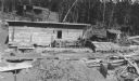
| Date: | 08 1937 |
|---|---|
| Description: | Lumber is stacked in three large piles behind a small wooden shed. There is machinery in front of the shed on the right, and what appears to be a saw pit o... |
If you didn't find the material you searched for, our Library Reference Staff can help.
Call our reference desk at 608-264-6535 or email us at: