 Filter: Categories of Wisconsin Historical Images
Filter: Subject of Sawmills
Filter: County of Ashland
Filter: Year of 1900-1999
Filter: Categories of Wisconsin Historical Images
Filter: Subject of Sawmills
Filter: County of Ashland
Filter: Year of 1900-1999
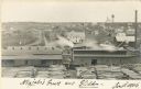
| Date: | 1906 |
|---|---|
| Description: | Elevated view of a sawmill and the distant town in the background. Stacks of logs are in the lumberyard. Along the bottom is a New Year's greeting in Germa... |

| Date: | 06 1923 |
|---|---|
| Description: | Sanborn map of Ashland, which includes Chequamegon Bay. |

| Date: | 1909 |
|---|---|
| Description: | This map shows vacant Wisconsin Central Ry. lands, settlers houses, lands sold by Wisconsin Central Ry., schools, churches, saw mills, and roads; also show... |
If you didn't find the material you searched for, our Library Reference Staff can help.
Call our reference desk at 608-264-6535 or email us at: