 Filter: Categories of Wisconsin Historical Images
Filter: Subject of Sawmills
Filter: Creator Name of Unknown
Filter: Categories of Wisconsin Historical Images
Filter: Subject of Sawmills
Filter: Creator Name of Unknown

| Date: | 1910 |
|---|---|
| Description: | Photographic postcard of a group of workers, horses, and a dog posing at railroad siding at C.W. Begg's Mill. Caption reads: "C.W. Begg's Mill at Siding, C... |

| Date: | 1876 |
|---|---|
| Description: | This map is ink on tracing cloth and shows the Black River, French Slough, Little French Slough, the southern portion of North La Crosse, the Milwaukee & S... |

| Date: | 1891 |
|---|---|
| Description: | This map shows vacant Southwick & Sellers lands, settlers' houses, Goodland Co. land, schools, churches, saw mills, roads, and railroads. A key in the uppe... |

| Date: | 1909 |
|---|---|
| Description: | This map shows vacant Wisconsin Central Ry. lands, settlers houses, lands sold by Wisconsin Central Ry., schools, churches, saw mills, and roads; also show... |

| Date: | 1910 |
|---|---|
| Description: | Two men, left, are standing near the circular blade of a sawmill which is set up in a forested area. A third man in the center is peering over a pile of lu... |
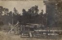
| Date: | 1908 |
|---|---|
| Description: | View of a portable mill, a wagon, and lumber in a forest clearing. Caption reads: "Portable Mill at Butler's Camp, Mattoon, Wis." |

| Date: | 1875 |
|---|---|
| Description: | Elevated view of several buildings, with bridge and railroad tracks, and the Fox River. In the foreground on the right is the Commercial House, with three ... |
If you didn't find the material you searched for, our Library Reference Staff can help.
Call our reference desk at 608-264-6535 or email us at: