 Filter: Categories of Wisconsin Historical Images
Filter: Subject of Sawmills
Filter: Creator Name of Unknown
Filter: Subject of human settlements
Filter: Year of 1900-1999
Filter: Categories of Wisconsin Historical Images
Filter: Subject of Sawmills
Filter: Creator Name of Unknown
Filter: Subject of human settlements
Filter: Year of 1900-1999

| Date: | 1905 |
|---|---|
| Description: | Elevated view of Soldiers' Grove with a bridge in the foreground. |
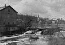
| Date: | 1948 |
|---|---|
| Description: | Elevated view from shoreline towards the opposite shoreline towards the Buettner mill on the left, and the river with a dam, on the right. In the backgroun... |
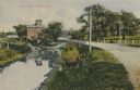
| Date: | 1910 |
|---|---|
| Description: | Distant view of the mill, with a stream leading to it, and a road paralleling the stream on the right. Caption reads: "The Old Mill, Delavan, Wis." |
| Date: | 1900 |
|---|---|
| Description: | View up the Eau Claire River from the Dewey Street Bridge. The view shows the dam and linen mill and the site of the lower sawmill (called the "steam mill"... |
| Date: | 1905 |
|---|---|
| Description: | Sawmill with trees, stumps, and lumber in the snow. |
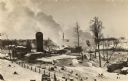
| Date: | 1906 |
|---|---|
| Description: | Elevated view of a sawmill and the distant town in the background. Stacks of logs are in the lumberyard. Along the bottom is a New Year's greeting in Germa... |
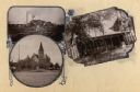
| Date: | 1900 |
|---|---|
| Description: | Composite of views of Oakwood Beach Lodge, Pioneer Presbyterian Church and a sawmill. |

| Date: | 1930 |
|---|---|
| Description: | Holt Lumber Company sawmill, built in 1840. |
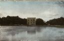
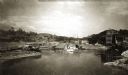
| Date: | 1905 |
|---|---|
| Description: | View across water towards the old mill building on the opposite shoreline. Caption reads: "The Old Mill, Osceola, Wis." |

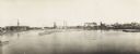
| Date: | 1902 |
|---|---|
| Description: | Two panoramic bird's-eye views of the Paine Lumber Company, including the general plant, sawmill, and lumber yards. Heading at the top says: Home of Wiscon... |

| Date: | 1914 |
|---|---|
| Description: | This map is a photostat copy from the original 1829 map in the War Department. The map shows location of Fort Howard, lots, land claims of Jacques Porlier ... |

| Date: | 1909 |
|---|---|
| Description: | A map of Langlade County, Wisconsin that shows townships and ranges, towns, cities and villages, wagon roads, churches, schools, sawmills, town halls, chee... |

| Date: | 1909 |
|---|---|
| Description: | This 1909 map of Taylor County, Wisconsin, shows the township and range grid, towns, sections, cities and villages, settlers houses, schools, churches, saw... |
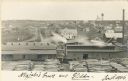
| Date: | 1900 |
|---|---|
| Description: | Semi-panoramic view of a river town showing extensive sawmill operations. |

| Date: | 1909 |
|---|---|
| Description: | This map shows vacant Wisconsin Central Ry. lands, settlers houses, lands sold by Wisconsin Central Ry., schools, churches, saw mills, and roads; also show... |
If you didn't find the material you searched for, our Library Reference Staff can help.
Call our reference desk at 608-264-6535 or email us at:
