 Filter: Categories of Wisconsin Historical Images
Filter: Subject of Sailing ships
Filter: Subject of land use, rural
Filter: Categories of Wisconsin Historical Images
Filter: Subject of Sailing ships
Filter: Subject of land use, rural
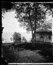
| Date: | 1874 |
|---|---|
| Description: | Partial view of billiard hall and Lake Mendota from the Ole Bull Residence, 130 East Gilman Street. Two people on shore are pointing to a sailboat. Later, ... |

| Date: | 1829 |
|---|---|
| Description: | Hand-colored lithograph of Fort Armstrong, based on a drawing by Henry Lewis. Includes boats on the Mississippi River. |

| Date: | 1790 |
|---|---|
| Description: | This map of the north eastern states shows roads, rivers, lakes, waterfalls, mountains, cities, forts, mills, the Oneida Reservation, and "New York Donatio... |

| Date: | 1776 |
|---|---|
| Description: | Map of New Jersey and New York, showing cities, forts, roads, counties, townships, land grants, rivers, lakes and several topographical features. Much of t... |
If you didn't find the material you searched for, our Library Reference Staff can help.
Call our reference desk at 608-264-6535 or email us at: