 Filter: Categories of Wisconsin Historical Images
Filter: Subject of Sailing ships
Filter: Subject of human settlements
Filter: County of Door
Filter: Categories of Wisconsin Historical Images
Filter: Subject of Sailing ships
Filter: Subject of human settlements
Filter: County of Door

| Date: | 1893 |
|---|---|
| Description: | Bird's-eye map of Sturgeon Bay, looking Northeast. Area bordered by Church Street in top left corner, leather & Smith Bridge in bottom left corner, Lawrenc... |
| Date: | 1915 |
|---|---|
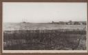
| Description: | View from shoreline over water towards a three-masted sailing vessel docked at Baileys Harbor pier. Houses and commercial buildings line the shore. |

| Date: | 1966 |
|---|---|
| Description: | A colored map depiction of Door County, Wisconsin, with pictorial highlights, titled: "Door County — Wisconsin's Air Conditioned Peninsula Playground." |
| Date: | |
|---|---|
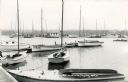
| Description: | View of the marina, with several docked sailboats. The tree-lined shoreline is in the background. Caption reads: "Busy Pier Scene, Fish Creek, Wis." |
| Date: | |
|---|---|
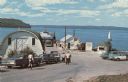
| Description: | View down road towards the ferry dock at Gills Rock. A ferry is unloading cars. A line of cars and a group of people are waiting to get on the ferry. |
If you didn't find the material you searched for, our Library Reference Staff can help.
Call our reference desk at 608-264-6535 or email us at: