 Filter: Categories of Wisconsin Historical Images
Filter: Subject of Rural areas
Filter: Categories of Wisconsin Historical Images
Filter: Subject of Rural areas
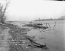
| Date: | 05 25 1910 |
|---|---|
| Description: | A man stands on the wreckage of a burned steamer in the Mississippi River near the shoreline. There is a small boat and a barrel nearby. Bluffs are in the ... |

| Date: | 1914 |
|---|---|
| Description: | Exterior view of a small brick public school on a hillside. There is a bell in a small bell tower above the entrance. |

| Date: | 07 1929 |
|---|---|
| Description: | View uphill towards the entrance to the McSherry Cave. A woman is standing at the entrance. Trees and shrubs are growing on top of the cave. |
| Date: | 1916 |
|---|---|
| Description: | Three-quarter view from front of the public school, which is a two-story wood frame building with a belfry. There are two doors at the front of the buildin... |
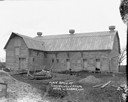
| Date: | |
|---|---|
| Description: | View of an L-shaped stone barn. Piles of sand, broken wood and an old plow are in the foreground. |
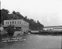
| Date: | 1922 |
|---|---|
| Description: | Elevated view across water of a stone building next to an earthen dam on the La Crosse River. There is an archway on the side of the building at the river ... |
| Date: | 1911 |
|---|---|
| Description: | Map shows routes, post offices, houses, churches, schools, and roads of La Fayette County rural delivery service. The map margins read: "G. January 11, 191... |

| Date: | 1908 |
|---|---|
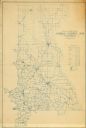
| Description: | Map shows townships and sections, landownership and acreages, rural routes, roads, railroads, creameries, churches, schools, and town halls. Sections appea... |

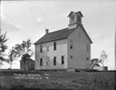
| Date: | 1911 |
|---|---|
| Description: | Three-quarter view of the Methodist Evangelical Church on a hillside. It has a belfry with no steeple and windows shaped like elongated pentagons. |

| Date: | 1925 |
|---|---|
| Description: | View of a public school on a hilltop, which is a one-story brick building with a chimney and a belfry. |

| Date: | 1911 |
|---|---|
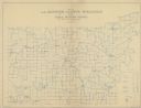
| Description: | Map shows in blue roads, railroads, post offices, schools, houses, churches, and routes. The map includes a chart of "Explanation" that acts as a legend. T... |
| Date: | 1912 |
|---|---|
| Description: | Map shows roads, railroads, post offices, schools, houses, churches, routes, and post office collection boxes. The map includes a distant chart and explana... |

| Date: | 09 21 1931 |
|---|---|
| Description: | Tornado damage showing a broken, twisted tree laying on the ground and on the roof of a farmhouse. The roof and wall have been crushed. |

| Date: | 09 21 1931 |
|---|---|
| Description: | View from road of storm damage to a farm. The barn roof has blown off. Men are working on the roof, which has exposed roof timbers. In the foreground are t... |

| Date: | 1910 |
|---|---|
| Description: | Map is a blueline print. Map shows United States postal routes for La Crosse County. A list of stations include: Bangor R R 1-3, Holmen R R 1-2, La Crosse ... |
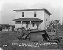
| Date: | 08 07 1924 |
|---|---|
| Description: | View across yard of a storm-damaged farmhouse. In the foreground is an overturned automobile. The windows of the house have been blown out and the roof has... |
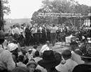
| Date: | 08 16 1925 |
|---|---|
| Description: | A chorus of men singing on stage with a crowd watching. A group of officials seated on the right. Rolling farmland in the background. |

| Date: | 08 16 1925 |
|---|---|
| Description: | View of field full of parked automobiles at the commemoration of the 80th anniversary of the founding of the Swiss Colony at New Glarus. A log structure in... |
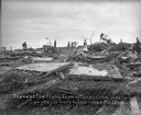
| Date: | 06 12 1915 |
|---|---|
| Description: | People standing among the broken remains of the Tim Finley farm after a killer tornado. A woman in the center is standing on a mattress. Two people were ki... |
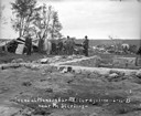
| Date: | 06 12 1915 |
|---|---|
| Description: | Group of men and boys standing around the exposed foundation of a house in the foreground. There is part of an overturned roof on the left. Broken wood is ... |
If you didn't find the material you searched for, our Library Reference Staff can help.
Call our reference desk at 608-264-6535 or email us at: