 Filter: Categories of Wisconsin Historical Images
Filter: Subject of Roads
Filter: Year of 1800-1899
Filter: Categories of Wisconsin Historical Images
Filter: Subject of Roads
Filter: Year of 1800-1899

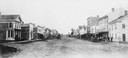
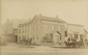
| Date: | 1873 |
|---|---|
| Description: | Main Street, with its dirt, ruts, cows (and presumably manure), but wide enough for easy hitching of wagons and teams. |
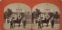
| Date: | 1860 |
|---|---|
| Description: | College Avenue looking west from the corner of Morrison Street. The building on the left is the Adkins Building, at the right is the Johnston House. This w... |
| Date: | 1890 |
|---|---|
| Description: | Several houses at the intersection of Wilson Street and Monona Avenue with the home of Simeon Mills, one of Madison's most prominent citizens, on the corne... |
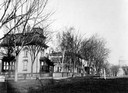
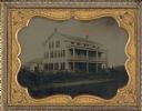
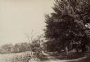
| Date: | 1890 |
|---|---|
| Description: | Bucolic scene in Wisconsin illustrates agricultural prosperity after the depression. |
| Date: | 1898 |
|---|---|
| Description: | Horse-drawn carriage stuck in a rut on a muddy road near the Ohio River in Floyd County, Indiana. One man is holding the horse while another attempts to di... |
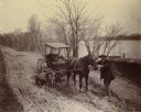
| Date: | 1890 |
|---|---|
| Description: | Two men ride their bicycles past curious on-lookers. |
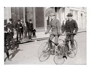
| Date: | 1876 |
|---|---|
| Description: | Stereograph. This view from East Washington Avenue shows photographer Andrew Dahl on his horse "Curnel" in front of the Wisconsin State Capitol. Dahl had j... |
| Date: | 1873 |
|---|---|
| Description: | Elevated view of railroad tracks and several houses. Several railroad employees are doing repair work on the tracks, and one man is riding on a handcar. Be... |

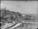
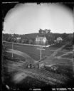
| Date: | 1870 |
|---|---|
| Description: | This bird's-eye-view map shows roads, a river with boats, and homes. The bottom margin of the map includes an index. |
| Date: | 1858 |
|---|---|
| Description: | Ambrotype of the Wade House, a carriage inn located in Greenbush, also showing a section of the original plank road in the foreground. |
| Date: | 1885 |
|---|---|
| Description: | Exterior view of Fauerbach's Brewery at 651-53 Williamson Street. |
| Date: | 1897 |
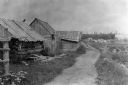
|---|---|
| Description: | Dirt trail passing log shack that was probably the home of Michael and Madeline Cadotte. |

| Date: | 1886 |
|---|---|
| Description: | Bird's-eye view of Ashland, on the shores of Lake Superior, with insets of The Apostle Islands Chequamagon Bay & Ashland, and Distances from Ashland. |
| Date: | 1890 |
|---|---|
| Description: | Hagerstown Pike. A brick wall and trees are along the road on the right. |

| Date: | 1874 |
|---|---|
| Description: | This map shows lakes, rivers, state, county, and town boundaries, as well as railroads completed, in progress, and contemplated. The map includes a color d... |

| Date: | 1885 |
|---|---|
| Description: | Chromolithograph advertising poster produced for the McCormick Harvesting Machine Company showing a McCormick binder stored in a shed in the middle of the ... |

| Date: | 1873 |
|---|---|
| Description: | Map of the township of Windsor, from the "Atlas of Dane County." |
| Date: | 1888 |
|---|---|
| Description: | Exterior view of Charles Pfeifer's Drugstore, founded in 1858. From left to right are Charles Pfeifer, Fred Pfeifer, Mrs. Adam Heeb, Fulda Pfeifer, Mrs. Ch... |
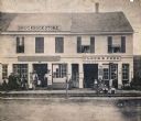
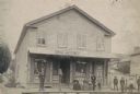
| Date: | 1864 |
|---|---|
| Description: | Street scene with customers in front of the M.P. Roberts Drugstore and C. Baack Flour and Feed Store. |
If you didn't find the material you searched for, our Library Reference Staff can help.
Call our reference desk at 608-264-6535 or email us at:
