 Filter: Categories of Wisconsin Historical Images
Filter: Subject of Roads
Filter: Year of 2000-Present
Filter: Year of 2010-2019
Filter: Categories of Wisconsin Historical Images
Filter: Subject of Roads
Filter: Year of 2000-Present
Filter: Year of 2010-2019

| Date: | 2013 |
|---|---|
| Description: | Map is the most extensive endeavor to date to accurately locate and document both prehistoric place names and natural features of the Menominee language wi... |
| Date: | 03 05 2012 |
|---|---|
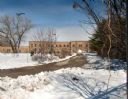
| Description: | Exterior view of the Garver Feed and Supply Company building, which formerly housed the U.S. Sugar Company. Snow is on the ground. |
| Date: | 03 04 2012 |
|---|---|
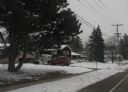
| Description: | View down road toward a house at 4718 Odana Road, the former location of the Piper Brothers farm. An automobile is parked in the driveway, and snow is on t... |
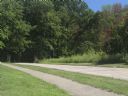
| Date: | 04 25 2012 |
|---|---|
| Description: | A view of the approach to the Village of Blue Mounds from the cemetery. |
| Date: | 03 18 2012 |
|---|---|
| Description: | Elevated view across road of a house on Highway 39 between Linden and Mineral Point. There is a swing-set in the yard and a large recreational vehicle park... |

| Date: | 03 31 2012 |
|---|---|
| Description: | View from road of Brown School, a brick school building near Fennimore. |
| Date: | 08 06 2012 |
|---|---|
| Description: | The north entrance to Devil's Lake State Park. The entrance is flanked by two fieldstone pillars. |
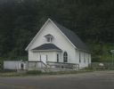
| Date: | 07 27 2012 |
|---|---|
| Description: | Exterior view of the Methodist Evangelical Church, with stairs and a ramp at the front of the building. |

| Date: | 04 19 2012 |
|---|---|
| Description: | View towards the curve of Darlington Road when approaching Blanchardville. |
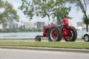
| Date: | 2010 |
|---|---|
| Description: | A man drives a tractor on John Nolen Drive along Lake Mendota with the Wisconsin State Capitol in the distance. He is on his was to a Red Power venue held ... |

| Date: | 09 2013 |
|---|---|
| Description: | Elevated view of University Avenue from a footbridge. The University of Wisconsin Foundation and a parking lot are on the opposite side of the avenue. A Ba... |

| Date: | 09 2013 |
|---|---|
| Description: | View looking down through the branches of locust trees at railroad tracks that run along University Avenue. |

| Date: | 10 2013 |
|---|---|
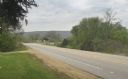
| Description: | View through car windshield of road signs above Interstate 90. The exit for highway 12/18 towards Cambridge is on the right, and the exit for 12/18 towards... |

| Date: | 10 2013 |
|---|---|
| Description: | Two roads converge forming a crossroads. There are three utility poles standing in an open field of tall grass along Enchanted Valley Road which stretches ... |

| Date: | 11 2013 |
|---|---|
| Description: | Trees lining a dirt road covered in a light layer of snow in the Driftless Area. A rock outcropping is on the far left. |
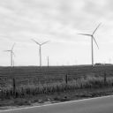
| Date: | 11 2013 |
|---|---|
| Description: | View across fence-lined road towards windmills and power lines in a field. A small wire fence separates the field from the road. Farm buildings are in the ... |
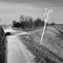
| Date: | 11 2013 |
|---|---|
| Description: | View along right side of car towards a railroad crossing at a gravel road in Dekalb County. The railroad tracks lead off to the right along a farm field. T... |

| Date: | 02 2014 |
|---|---|
| Description: | View down a large snow bank along Mineral Point Road. There are trees in the distance. |
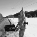
| Date: | 03 2014 |
|---|---|
| Description: | Close-up of a life-sized tin man sculpture with a hatchet attached to his side holding two mailboxes at the side of Highway 78. Snow is covering the ground... |
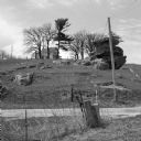
| Date: | 05 2014 |
|---|---|
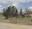
| Description: | View across fence and road towards a house on a hill of outcroppings in the Driftless Area. There are fence lines, telephone and electric poles, and a few ... |
If you didn't find the material you searched for, our Library Reference Staff can help.
Call our reference desk at 608-264-6535 or email us at: