 Filter: Categories of Wisconsin Historical Images
Filter: Subject of Roads
Filter: Year of 2000-Present
Filter: Categories of Wisconsin Historical Images
Filter: Subject of Roads
Filter: Year of 2000-Present
| Date: | 08 16 2002 |
|---|---|
| Description: | "Today we traveled nearly to Lake Michigan, and dined in the small community of Lake Church at the Lake Church Inn, 69 Hwy D. Belgium, WI." |
| Date: | 10 24 2003 |
|---|---|
| Description: | "On a cool, rainy evening, we visit the Country Inn on Silver Lake. Their address is 5602 Peters Drive, West Bend." |
| Date: | 03 30 2008 |
|---|---|
| Description: | "Today we visit Jerry's Old Town Inn at N116 W15841 Main Street, Germantown." |

| Date: | 10 16 2009 |
|---|---|
| Description: | "This is the Rawhide Boys Ranch, E7475 Rawhide Road, New London." Note the sign about the fish fry. |

| Date: | 2004 |
|---|---|
| Description: | Jeff and Kris Jaster live at N8277 Hwy 1775. |

| Date: | 2004 |
|---|---|
| Description: | This sign gets your attention when you pull into the long Battisti driveway at W2476 Zion Church Rd. |

| Date: | 2004 |
|---|---|
| Description: | Steve and Nancy Grulke and children, Alison, Cassandra, and Paul, live at W2346 Zion Church Rd (Section 30). Steve has lived here all his life. Steve and N... |

| Date: | 2004 |
|---|---|
| Description: | Cliff and Renoda pose by this old granary. |

| Date: | 2013 |
|---|---|
| Description: | Map is the most extensive endeavor to date to accurately locate and document both prehistoric place names and natural features of the Menominee language wi... |
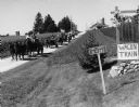
| Date: | 09 2000 |
|---|---|
| Description: | Wagon Train organized by Everett Schultz family living on Pole Road. |

| Date: | 09 2000 |
|---|---|
| Description: | Wagon Train continues on McArther Road. |
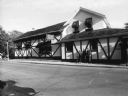
| Date: | 03 05 2012 |
|---|---|
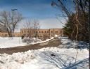
| Description: | Exterior view of the Garver Feed and Supply Company building, which formerly housed the U.S. Sugar Company. Snow is on the ground. |
| Date: | 03 04 2012 |
|---|---|
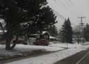
| Description: | View down road toward a house at 4718 Odana Road, the former location of the Piper Brothers farm. An automobile is parked in the driveway, and snow is on t... |
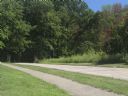
| Date: | 04 25 2012 |
|---|---|
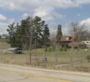
| Description: | A view of the approach to the Village of Blue Mounds from the cemetery. |
| Date: | 03 18 2012 |
|---|---|
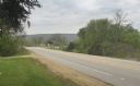
| Description: | Elevated view across road of a house on Highway 39 between Linden and Mineral Point. There is a swing-set in the yard and a large recreational vehicle park... |

| Date: | 2008 |
|---|---|
| Description: | This double sided map shows roads, railroads, biking trails, civil townships, parks, wildlife refuges, town halls, and hospitals. The region map covers par... |

| Date: | 2000 |
|---|---|
| Description: | This map shows Wisconsin Public Service Corporation property, special regulation areas, public boat landings, roads, parks, and other recreation areas. Ins... |

| Date: | 03 31 2012 |
|---|---|
| Description: | View from road of Brown School, a brick school building near Fennimore. |
| Date: | 08 06 2012 |
|---|---|
| Description: | The north entrance to Devil's Lake State Park. The entrance is flanked by two fieldstone pillars. |
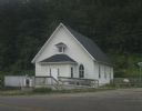
| Date: | 07 27 2012 |
|---|---|
| Description: | Exterior view of the Methodist Evangelical Church, with stairs and a ramp at the front of the building. |
If you didn't find the material you searched for, our Library Reference Staff can help.
Call our reference desk at 608-264-6535 or email us at: