 Filter: Categories of Wisconsin Historical Images
Filter: Subject of Roads
Filter: Year of 1800-1899
Filter: Year of 1880-1889
Filter: Categories of Wisconsin Historical Images
Filter: Subject of Roads
Filter: Year of 1800-1899
Filter: Year of 1880-1889
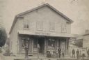
| Date: | 1885 |
|---|---|
| Description: | Exterior view of Fauerbach's Brewery at 651-53 Williamson Street. |

| Date: | 1886 |
|---|---|
| Description: | Bird's-eye view of Ashland, on the shores of Lake Superior, with insets of The Apostle Islands Chequamagon Bay & Ashland, and Distances from Ashland. |

| Date: | 1885 |
|---|---|
| Description: | Chromolithograph advertising poster produced for the McCormick Harvesting Machine Company showing a McCormick binder stored in a shed in the middle of the ... |
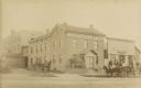
| Date: | 1888 |
|---|---|
| Description: | Exterior view of Charles Pfeifer's Drugstore, founded in 1858. From left to right are Charles Pfeifer, Fred Pfeifer, Mrs. Adam Heeb, Fulda Pfeifer, Mrs. Ch... |

| Date: | 1886 |
|---|---|
| Description: | Bird's-eye view of Bayfield, county seat of Bayfield County. On the lower left side is an inset for Bayfield and the Apostle Islands. |
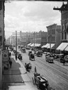
| Date: | 1885 |
|---|---|
| Description: | Elevated view of buildings and street traffic. |
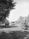
| Date: | 1885 |
|---|---|
| Description: | View looking up Grand Avenue from 9th Street toward two horse-drawn wagons and a horse-drawn streetcar on the tree-lined street. The wagon on the right is ... |
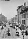
| Date: | 1885 |
|---|---|
| Description: | Elevated view of West Water Street from Grand Avenue of horse-drawn vehicles, pedestrians, buildings, storefronts and power lines. |
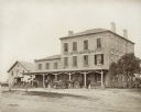
| Date: | 1880 |
|---|---|
| Description: | 2504 Forest Home Avenue. This hotel was situated on what was originally a plank road between Milwaukee and Muskego. It was designed after the Federal style... |
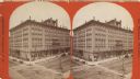
| Date: | 1880 |
|---|---|
| Description: | Stereograph of elevated view of Newhall House which was destroyed by fire in 1883. |

| Date: | 1884 |
|---|---|
| Description: | Bird's-eye map of Delavan with inset of the State Institute for Deaf and Dumb. |

| Date: | 1886 |
|---|---|
| Description: | Bird's-eye map of Hurley with insets Mining at the Colby, Hurley in 1885, and North Front of Silver Street. |

| Date: | 1885 |
|---|---|
| Description: | Bird's-eye map of Madison, State Capital of Wisconsin, County Seat of Dane County, with inset of the Wisconsin State Capitol. |

| Date: | 1882 |
|---|---|
| Description: | Bird's-eye views of various sections of Milwaukee. |

| Date: | 1885 |
|---|---|
| Description: | Bird's-eye map of Oconomowoc. |

| Date: | 1885 |
|---|---|
| Description: | Bird's-eye view of Sheboygan, with inset of J.J. Volrath Manufacturing Company. |

| Date: | 1882 |
|---|---|
| Description: | Bird's-eye map of Lake Geneva, looking southwest, with insets of points of interest. |

| Date: | 1886 |
|---|---|
| Description: | Bird's-eye map of Menomonee Falls. |
If you didn't find the material you searched for, our Library Reference Staff can help.
Call our reference desk at 608-264-6535 or email us at:

