 Filter: Categories of Wisconsin Historical Images
Filter: Subject of Roads
Filter: Year of 1800-1899
Filter: Year of 1840-1849
Filter: Categories of Wisconsin Historical Images
Filter: Subject of Roads
Filter: Year of 1800-1899
Filter: Year of 1840-1849
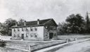
| Date: | 1848 |
|---|---|
| Description: | Sketch of the Madison Women's Seminary on the corner of Wisconsin Avenue and East Johnson. The Madison Female Academy was a 19th century school for girls w... |
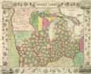
| Date: | 1849 |
|---|---|
| Description: | Map reads, "Map of the Western States". Published by Ensign & Thayer. There is a decorative vine border, and in each corner there is an engraving of four c... |

| Date: | 1844 |
|---|---|
| Description: | Part of a series of local maps, showing a number of burial mounds in the shape of animals near Madison, Wisconsin along military road. The maps also show d... |

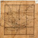
| Date: | 1840 |
|---|---|
| Description: | This hand-colored map shows the township and section grid in southeastern Wisconsin, covering the area west to Sugar River and Four Lakes region and north ... |

| Date: | 1844 |
|---|---|
| Description: | Wisconsin was considered part of Michigan Territory until 1836, a year before Michigan entered statehood. Drawn four years before Wisconsin entered stateho... |

| Date: | 1845 |
|---|---|
| Description: | Wisconsin was considered part of Michigan Territory until 1836, a year before Michigan entered statehood. Drawn three years before Wisconsin entered stateh... |

| Date: | 05 1846 |
|---|---|
| Description: | Hand-colored map of southeastern Wisconsin showing the counties of Dodge, Jefferson, Rock, Walworth, Racine (including modern-day Kenosha County), Waukesha... |

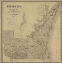
| Date: | 1848 |
|---|---|
| Description: | Wisconsin became the thirtieth state in 1848. Drawn that same year, this map shows township lines, roads, villages, mills, railroads, prairies, swamps, can... |

| Date: | 1848 |
|---|---|
| Description: | This map by Increase Lapham shows the township and range system in southern and eastern Wisconsin as well as along the Wisconsin River in present-day Marat... |
| Date: | 1848 |
|---|---|
| Description: | This map shows the township and range system in southern and eastern Wisconsin as well as along the Wisconsin River in present-day Marathon, Portage, and W... |

| Date: | 1840 |
|---|---|
| Description: | An ink, watercolor, and pencil on tracing paper, hand-drawn map of Milwaukee County, Wisconsin that shows the town and range system, sections, lakes and st... |

| Date: | 1844 |
|---|---|
| Description: | An ink on paper, hand-drawn map of Milwaukee County that shows the sectioning of townships, the boundary of the canal grant, roads, streams, lakes, includi... |
| Date: | 1845 |
|---|---|
| Description: | This manuscript map, drawn about 1845, shows the township and range grid, villages, post offices, and roads in Kenosha, Racine, and Walworth counties and i... |
| Date: | 1840 |
|---|---|
| Description: | This 19th century manuscript map shows the roads and proposed routes, villages, and lakes and streams in Walworth County, Wisconsin. |

| Date: | 1840 |
|---|---|
| Description: | This manuscript map by Increase Lapham shows the railroads, roads, wetlands, lakes and streams, dams, prairies, and settlers in the eastern half of Waukesh... |

| Date: | 1842 |
|---|---|
| Description: | Relief shown by hachures. Shows furnaces, saw mills, houses, roads, grist mills, entries, reservations, and diggings. "Compiled by order of the Board of C... |
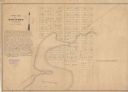
| Date: | 1849 |
|---|---|
| Description: | The map reads: "Dartford is centrally located in Wisconsin, on the north side of Green Lake, and in full view of that beautiful sheet of Water. Its precise... |

| Date: | 1848 |
|---|---|
| Description: | Pen-and-ink on paper. The title of the map is inscribed on the back. The map shows buildings, roads, marshes, wild rice, piles and docks, deep water, and o... |

| Date: | 1840 |
|---|---|
| Description: | Map shows three Wisconsin territories, Jefferson, Waukesha, and Milwaukee. Map is ink, pencil, and watercolor on paper. Relief shown by hachures. |
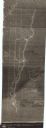
| Date: | 1840 |
|---|---|
| Description: | This map shows shows three routes; a route surveyed by Doty & Center, a route surveyed by inhabitants of East Milwaukee, and a route surveyed by inhabitant... |
If you didn't find the material you searched for, our Library Reference Staff can help.
Call our reference desk at 608-264-6535 or email us at: