Filter: Categories of Wisconsin Historical Images
Filter: Subject of Roads
Filter: Year of 1800-1899
Filter: Categories of Wisconsin Historical Images
Filter: Subject of Roads
Filter: Year of 1800-1899

| Date: | 1896 |
|---|---|
| Description: | Bird's-eye map of Darlington. Area bordered by Washington and North Streets, upper left hand corner, the fairgrounds, upper right corner, River Street, bot... |
| Date: | 1875 |
|---|---|
| Description: | Bird's-eye map of Dodgeville, looking east, with insets of the high school and county courthouse. |

| Date: | 1872 |
|---|---|
| Description: | Birds-eye drawing of Eau Claire depicts street names and street locations, houses, trees, bridges, piers, canals, railroads, and the Chippewa and Eau Clair... |

| Date: | 1879 |
|---|---|
| Description: | Bird's-eye map of Hartford. |

| Date: | 1892 |
|---|---|
| Description: | This bird's-eye view map is oriented looking north-east and includes index of points of interest and businesses. The map is a photocopy. |

| Date: | 1885 |
|---|---|
| Description: | Bird's-eye map of Hustisford. |

| Date: | 1878 |
|---|---|
| Description: | Bird's-eye map of Kewaskum. Includes a list of hotels, churches, post office, railroad depot, etc. |

| Date: | 1870 |
|---|---|
| Description: | Bird's-eye map of Kilbourn City, now known as Wisconsin Dells. Kilbourn City was platted in the 1850s and received a boost when the La Crosse and Milwaukee... |

| Date: | 1879 |
|---|---|
| Description: | Bird's-eye map of Lake Mills. |

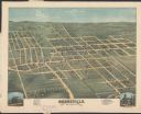
| Date: | 1874 |
|---|---|
| Description: | Bird's-eye map of Lodi, with inset of Public School. Includes index of churches and points of interest. |

| Date: | 1883 |
|---|---|
| Description: | Bird's-eye map of Marshfield, with one vignette. |

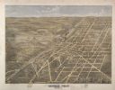
| Date: | 1875 |
|---|---|
| Description: | Bird's-eye map of Mazomanie. |

| Date: | 1898 |
|---|---|
| Description: | Bird's-eye map, looking west from shoreline on Lake Michigan of Milwaukee to Golden Lake in Waukesha County, with Kenosha and Fox Point at bottom corners, ... |
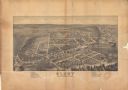
| Date: | 1872 |
|---|---|
| Description: | Bird's-eye map of Mineral Point, looking southeast. |
If you didn't find the material you searched for, our Library Reference Staff can help.
Call our reference desk at 608-264-6535 or email us at: