 Filter: Categories of Wisconsin Historical Images
Filter: Subject of Roads
Filter: Year of 1800-1899
Filter: Community of De Pere
Filter: Categories of Wisconsin Historical Images
Filter: Subject of Roads
Filter: Year of 1800-1899
Filter: Community of De Pere

| Date: | 1875 |
|---|---|
| Description: | Elevated view of a shopping district street near a river, with several businesses lining the street, and two carriages. A building across the street has le... |
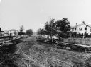
| Date: | 1870 |
|---|---|
| Description: | View of dirt road with houses along both sides, and wooden walkways and picket fences along the road. |

| Date: | 1870 |
|---|---|
| Description: | View of the California house next to a store with a sign that reads: "M. Silber & Bro.," and a "Boot & Shoe Store." A bakery is on the left, and a group of... |

| Date: | 1893 |
|---|---|
| Description: | Bird’s-eye view of Depere looking North. Includes illustrations and an index to points of interest. |

| Date: | 1870 |
|---|---|
| Description: | Section of overall panorama, showing railroad station. |

| Date: | 1875 |
|---|---|
| Description: | View over town looking east from the railroad station. |

| Date: | 1800 |
|---|---|
| Description: | This map shows plat of the town, local streets, plank roads, and part of the Fox River. The bottom of the map includes annotations, probably in pencil. |

| Date: | 1850 |
|---|---|
| Description: | This photocopied map shows lot and block numbers, selected buildings, street names and state lock located on the Fox River. Includes a description of Deper... |
If you didn't find the material you searched for, our Library Reference Staff can help.
Call our reference desk at 608-264-6535 or email us at: