 Filter: Categories of Wisconsin Historical Images
Filter: Subject of Roads
Filter: Subject of wisconsin
Filter: Categories of Wisconsin Historical Images
Filter: Subject of Roads
Filter: Subject of wisconsin

| Date: | 06 27 1927 |
|---|---|
| Description: | Aerial view of the effigy mound on Henry Wehmhoff's Riverview Farm. State Trunk Highway 83 runs through the effigy. |

| Date: | 1915 |
|---|---|
| Description: | A row of conical burial mounds adjoins the Park and Pleasure Drive on the north shore of Lake Wingra (now Edgewood Drive, at the south edge of Edgewood Col... |
| Date: | |
|---|---|
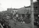
| Description: | Crowds of individuals assembled on the sides of the street to watch parading soldiers, and Native Americans riding horses. Looking east on Main Street from... |

| Date: | |
|---|---|
| Description: | View down wooden sidewalk towards a Ho-Chunk man smoking a cigar and wearing a duck bone breast plate and fur pants on the left, and a European American ma... |

| Date: | |
|---|---|
| Description: | Letterhead of the Kewaskum Mutual Fire Insurance Company of Washington County, Wisconsin, with a Native American man wearing buckskin clothes and leggings ... |

| Date: | 1943 |
|---|---|
| Description: | A map that shows the lands for sale by the Tomahawk Land Company of Tomahawk, Wisconsin, in the counties of Langlade, Lincoln, Oneida, and Price. The map s... |

| Date: | 1880 |
|---|---|
| Description: | A hand-colored map of the Chippewa, Price, Taylor and the northern part of Clark counties, which shows the locations of farmhouses, schoolhouses, churches,... |

| Date: | 1865 |
|---|---|
| Description: | This map of the entire state of Wisconsin depicts the township survey grid and identifies counties, named towns, cities and villages, rivers, lakes, railro... |

| Date: | 1922 |
|---|---|
| Description: | A map of Iron County, Wisconsin, shows sections and the towns of Upson, Hurley, Hamilton, Saxon, and Mercer, lakes and streams, villages, railroads, roads ... |

| Date: | 1945 |
|---|---|
| Description: | This maps shows roads, railroads, parks, recreational areas, Lake Wingra, Lake Monona, and part of Lake Mendota. The map includes pictorial images that dep... |

| Date: | 1836 |
|---|---|
| Description: | This map was created to accompany a congressional report shows the then Wisconsin Territory, including present-day states of Wisconsin, Minnesota, Iowa, an... |

| Date: | 1939 |
|---|---|
| Description: | This illustrated map shows counties, highways, rivers, roads, present and proposed state parks and forests, proposed state parkways, proposed state monumen... |

| Date: | 1923 |
|---|---|
| Description: | This map shows counties, roads, Lake Superior, Lake Michigan, and portions of surrounding states. Included is an index to cities, villages and other places... |

| Date: | 1921 |
|---|---|
| Description: | This map shows counties, roads, Lake Superior, Lake Michigan, and portions of surrounding states. Included is an index to cities, villages and other places... |

| Date: | 10 1911 |
|---|---|
| Description: | This map shows lot numbers, building lines, roads, trees, and Indian mounds. Relief is shown by contours. Includes manuscript annotations marking parks. |

| Date: | 1929 |
|---|---|
| Description: | This map with north oriented to the upper left shows military forts, Indian villages, settler's houses with surnames, trading houses, lodges and encampment... |

| Date: | 1930 |
|---|---|
| Description: | A map of the site of a Native American village with a complex of linear raised garden beds and cache pits near Leeman. Also shown are a farmstead, road, an... |
| Date: | 1925 |
|---|---|
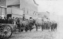
| Description: | View across unpaved road towards a Native American man wearing a plaid overcoat with two work horses. A crowd of men are watching from the elevated wooden ... |

| Date: | 1930 |
|---|---|
| Description: | View across muddy ground towards a man holding a dairy cow by the halter, and on the left a boy holding the lead of a heifer. They are standing in front of... |
If you didn't find the material you searched for, our Library Reference Staff can help.
Call our reference desk at 608-264-6535 or email us at: