 Filter: Categories of Wisconsin Historical Images
Filter: Subject of Roads
Filter: Subject of valleys
Filter: Categories of Wisconsin Historical Images
Filter: Subject of Roads
Filter: Subject of valleys

| Date: | 1958 |
|---|---|
| Description: | Aerial view of contour strip farming with the Obert Olstad farm in foreground. The Carl Backum farm is in the background. |

| Date: | 1882 |
|---|---|
| Description: | Bird's-eye views of various sections of Milwaukee. |
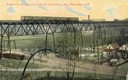
| Date: | 1911 |
|---|---|
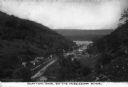
| Description: | Elevated view across valley toward a streetcar viaduct on the Waukesha Interurban Line, near Milwaukee. Caption reads: "Street Car Bridge on Waukesha Inter... |
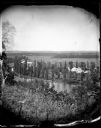
| Date: | |
|---|---|
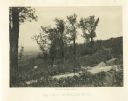
| Description: | View from hill over a valley dotted with farmsteads and a meandering stream in the foreground. A group of three or four people are posing at the opposite s... |
| Date: | 1876 |
|---|---|
| Description: | View, from above, of what may be the G. Gullockson farmstead. A frame house is in the left foreground, with a large group of men, women and children standi... |
| Date: | |
|---|---|
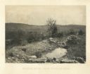
| Description: | View from hill overlooking a farmstead at the base of the hill with a windmill and a pond. On the right in the foreground, two men, one sitting, one standi... |

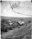
| Date: | 05 10 1928 |
|---|---|
| Description: | The Lutheran Church and buildings, seen from Lutheran Church Hill. |

| Date: | 11 1951 |
|---|---|
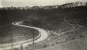
| Description: | Aerial view of US Highway 14 southeast of La Crosse descending into Mormon Coulee. The original caption of the print, which is undated, describes the road ... |
| Date: | 1920 |
|---|---|
| Description: | Loganville Road in Sauk County taken by the Wisconsin Good Roads Association. The photograph was meant to create a contrast between the new improved road ... |
| Date: | |
|---|---|
| Description: | Elevated view of the town in the valley, with houses, other buildings, a bridge, and roads. Caption reads: "General view of Loomis, Wash." |
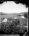
| Date: | |
|---|---|
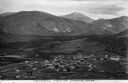
| Description: | An elevated view of the town of Clayton, Iowa, which is nestled in a valley. The Mississippi River can be seen nearby. Caption reads: "Clayton, Iowa, on th... |
| Date: | |
|---|---|
| Description: | Elevated view of two cars on a dirt road heading downhill. A town is in the valley below, and mountains are in the distance. |

| Date: | 1914 |
|---|---|
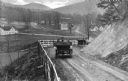
| Description: | Man and boy (possibly father and son) driving an International Model M truck on a rough dirt road overlooking farmland in a valley. |

| Date: | 1914 |
|---|---|
| Description: | Slightly elevated view of a man driving three women in an International Model M truck on a rural road with a guard rail. In the background is a valley with... |

| Date: | 1914 |
|---|---|
| Description: | Slightly elevated view of a man driving three women in an International Model M truck along a rural road. In the background is a valley with farm buildings... |

| Date: | |
|---|---|
| Description: | Elevated view of a town and body of water in a valley in Roldal, Norway. Two people in a horse-drawn vehicle are in the foreground on the road leading from... |
| Date: | 1866 |
|---|---|
| Description: | A road runs up the side of Mission Ridge with several trees. Trees and shrubs are in the foreground, overlooking a valley. Mountains are in the distance. |
| Date: | 1866 |
|---|---|
| Description: | A rocky ridge with bushes and scrub atop Mission Ridge is in the foreground. Orchard Knob is in the distance. The valley where the fighting took place is i... |

| Date: | 1864 |
|---|---|
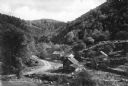
| Description: | View down to valley of Union soldiers posing on the roof of a log building. A log bridge crosses a stream, and many trees are on the hillsides. Plate 05... |
| Date: | |
|---|---|
| Description: | View of a mountain pass named Dunville Notch. A group of farmhouses are located among trees and a dirt road. |
If you didn't find the material you searched for, our Library Reference Staff can help.
Call our reference desk at 608-264-6535 or email us at: