 Filter: Categories of Wisconsin Historical Images
Filter: Subject of Roads
Filter: Subject of united states. army
Filter: Categories of Wisconsin Historical Images
Filter: Subject of Roads
Filter: Subject of united states. army

| Date: | 1945 |
|---|---|
| Description: | Aerial view of the "powder storage area" of the Badger Ordnance Plant. |

| Date: | 1865 |
|---|---|
| Description: | This map shows U.S. cavalry positions in yellow, Confederate infantry positions in blue, and Confederate cavalry positions in red. The map also shows roads... |

| Date: | 04 11 1940 |
|---|---|
| Description: | This blue line print map shows survey monument markers by type and industrial buildings and covers part of the lower Fox River and East River. The map incl... |
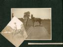
| Date: | 1900 |
|---|---|
| Description: | George W. Roskie (1876-?) poses with a horse in two photographs mounted in an album. The printed description reads: "G.W. Roskie, 1st Lieut 1st Reg Co K So... |
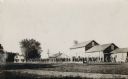
| Date: | 1909 |
|---|---|
| Description: | View across road and grass towards a group of soldiers marching through a Fox Lake neighborhood. |

| Date: | |
|---|---|
| Description: | U.S. Army officers — Captain McIntire and Major Ford. Military attachés from neutral countries, such as the United States, would have received permission t... |
If you didn't find the material you searched for, our Library Reference Staff can help.
Call our reference desk at 608-264-6535 or email us at: