 Filter: Categories of Wisconsin Historical Images
Filter: Subject of Roads
Filter: Subject of streetcars
Filter: Categories of Wisconsin Historical Images
Filter: Subject of Roads
Filter: Subject of streetcars
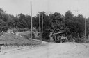
| Date: | 1886 |
|---|---|
| Description: | The first electric street railway in Wisconsin. |

| Date: | 1916 |
|---|---|
| Description: | Southeastern Wisconsin which lies east of Whitewater and south of Port Washington. |
| Date: | |
|---|---|
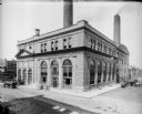
| Description: | The Oneida Street (East Wells) power plant, on the north side of Wells and east of the Milwaukee River. Presently, the building is the Milwaukee Repertory ... |
| Date: | |
|---|---|
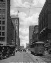
| Description: | View looking down Walnut Street in downtown which includes a trolley, pedestrians crossing the road, cars, and numerous buildings. Caption reads: "Looking ... |

| Date: | 1914 |
|---|---|
| Description: | Outdoor view of Union veterans standing near a war memorial in a square downtown. |
| Date: | 08 1948 |
|---|---|
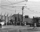
| Description: | View from road of crowd of people walking towards the entrance to the Wisconsin Centennial Exposition on Greenfield Avenue. |

| Date: | 1927 |
|---|---|
| Description: | Street railway and motor bus map with a legend of "Street Car Line," "Auxiliary Bus Lines," and "Motor Bus Lines." The routes are numbered. The map reads: ... |

| Date: | 1903 |
|---|---|
| Description: | Map shows railroads, roads, street car lines, schools, churches, cemeteries, town halls, and railroad stations. Includes inset lists of: Population of Milw... |

| Date: | 1960 |
|---|---|
| Description: | Color coded map in pink, yellow, blue, and brown of Milwaukee County State and County trunk highways. The map includes a legend of symbols: "STEAM RAIL ROA... |

| Date: | 1938 |
|---|---|
| Description: | Color coded map in pink, yellow, blue, and brown of Milwaukee County State and County trunk highways. The map includes a legend of symbols: "STEAM RAIL ROA... |

| Date: | 1918 |
|---|---|
| Description: | Elevated view of Troitsky prospect in Archangel [Archangelsk], Russia, looking south, showing homes, churches, state buildings, and a statue of Peter the G... |

| Date: | 1918 |
|---|---|
| Description: | Elevated view of Troitsky prospect in Archangel [Archangelsk], Russia, looking south, showing homes, churches, state buildings, as well as the statue of Pe... |

| Date: | 1901 |
|---|---|
| Description: | This map shows public schools, engine houses, railroads, street railways, city wards, parks, block numbers, and Lake Michigan. Also included are indexes, t... |

| Date: | 1927 |
|---|---|
| Description: | This map shows highways, roads, a proposed annexation, street car lines, bus routes, local motor bus lines, a new high speed interurban, railroads, a propo... |
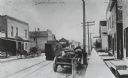
| Date: | |
|---|---|
| Description: | View from sidewalk on the right down a street, with horse-drawn wagons parked on the left and right curbs, and a streetcar in the center. A sign on the rig... |
If you didn't find the material you searched for, our Library Reference Staff can help.
Call our reference desk at 608-264-6535 or email us at: