 Filter: Categories of Wisconsin Historical Images
Filter: Subject of Roads
Filter: Subject of springs
Filter: Categories of Wisconsin Historical Images
Filter: Subject of Roads
Filter: Subject of springs

| Date: | 1910 |
|---|---|
| Description: | View from road toward Mineral Springs. There is a board sidewalk in the foreground. Caption reads: "Mineral Sprints, Green Bay, Wis." |
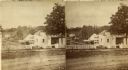
| Date: | 1877 |
|---|---|
| Description: | Stereograph view of Glenn's mineral spring. |
| Date: | |
|---|---|
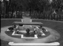
| Description: | Elevated view of a man and young girl relaxing at a natural-spring grotto park. The spring feeds a fountain set into a paved and sunken courtyard with an a... |
| Date: | |
|---|---|
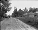
| Description: | The Chippewa Spring House, a small round building with a conical roof with a sign over the door reading "Chippewa Spring," sitting off to the side of a dir... |
| Date: | |
|---|---|
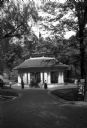
| Description: | View down wide walkway toward a group gathered outside the entrance to the Pluto Spring Pavillion in a a wooded area. In the foreground at right is an adve... |
| Date: | 1918 |
|---|---|
| Description: | This map shows the property owned by Edwin Bottomley and others at the confluence of Eagle Creek with the Fox River in the Town of Rochester, Racine County... |

| Date: | 1923 |
|---|---|
| Description: | This topographical map of Devil's Lake State Park, Sauk County, Wisconsin, is based on 1922-1923 surveys of the area by the University of Wisconsin Summer ... |

| Date: | |
|---|---|
| Description: | A hand-drawn map of Camp Curtis which was prepared for Colonel R. McMurphy. |
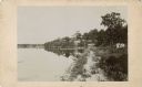
| Date: | 1885 |
|---|---|
| Description: | View along shoreline towards Tonyawatha House and several outbuildings on Lake Monona. There is a long dock extending into the lake from a boathouse on the... |

| Date: | 1864 |
|---|---|
| Description: | This map shows locations of quarries, sink holes, creeks, springs, rivers, houses, forts, and roads. Annotations in pencil read: "Is the top of the mound l... |

| Date: | 1864 |
|---|---|
| Description: | This map shows locations of quarries, sink holes, creeks, springs, rivers, houses, forts, and roads. The upper right corner and right margin includes anno... |

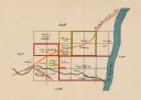
| Date: | 1864 |
|---|---|
| Description: | Map showing locations of quarries, sink holes, creeks, springs, rivers, houses, forts, and roads. The map appears to have been drawn on to of a plat map of... |

| Date: | 1864 |
|---|---|
| Description: | This map shows locations of quarries, sink holes, creeks, springs, rivers, houses, forts, and roads. |
If you didn't find the material you searched for, our Library Reference Staff can help.
Call our reference desk at 608-264-6535 or email us at: