 Filter: Categories of Wisconsin Historical Images
Filter: Subject of Roads
Filter: Subject of skis and skiing
Filter: Categories of Wisconsin Historical Images
Filter: Subject of Roads
Filter: Subject of skis and skiing
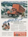
| Date: | 10 1947 |
|---|---|
| Description: | Advertising proof for International trucks, featuring a color illustration of a Model KBR-11 truck-tractor with semi-trailer. Includes the text: "Winter Tr... |

| Date: | 1978 |
|---|---|
| Description: | Three-quarter view from front of driver's side of white Scout II XLC. The Scout is being driven on a snowy road with trees in the background. A man appears... |

| Date: | 1978 |
|---|---|
| Description: | Three-quarter view from front of driver's side of white Scout II XLC. The Scout is being driven on a snowy road with trees in the background. A man appears... |

| Date: | 1975 |
|---|---|
| Description: | Two views of the U.S. Ski Team. Top: Alpine team practices near Park City, Utah headquarters. Bottom: Nordic team trains near Hanover, New Hampshire. |

| Date: | 1969 |
|---|---|
| Description: | This map shows ski areas, resorts, camps, special areas, airports, and roads. The map covers Vilas and Oneida counties and parts of Iron, Price, Lincoln, L... |

| Date: | 1960 |
|---|---|
| Description: | This pictorial map shows recreation activities, rivers, lakes, and the history of the area. The map covers Langlade County and parts of adjacent counties. ... |

| Date: | 1987 |
|---|---|
| Description: | This map shows federal highways, state or county highways, rivers, lakes, town roads, township boundaries, county boundaries, national or state forest, loo... |

| Date: | 1966 |
|---|---|
| Description: | This colored road map shows automobile roads in Wisconsin as well as portions of nearby states. A map key indicates relative sizes of cities and towns. On ... |

| Date: | 1966 |
|---|---|
| Description: | This colored road map shows automobile roads in Wisconsin as well as portions of nearby states. Information on the quality and type of any road shown (inte... |

| Date: | 1970 |
|---|---|
| Description: | This colored map displays detailed maps of Green Bay, Appleton, Racine, Milwaukee, Kenosha, and Duluth-Superior. At the top right is a map location list of... |

| Date: | 1971 |
|---|---|
| Description: | This colored map displays Wisconsin and bordering areas of Iowa, Minnesota, and Michigan. There is color-coding on the map to indicate National Forests, an... |

| Date: | 1973 |
|---|---|
| Description: | This colored map displays Wisconsin and bordering areas of Iowa, Minnesota, and Michigan. There is color-coding on the map to indicate National Forests, a... |

| Date: | 1975 |
|---|---|
| Description: | This colored road map of Wisconsin displays "Featured Points of Interest" and "Historical Points of Interest" in the state, including three color photograp... |

| Date: | 1976 |
|---|---|
| Description: | This colored map displays Wisconsin and portions of bordering states, including a detailed map of the Wisconsin Dells area. Surrounding the map are multipl... |

| Date: | 1977 |
|---|---|
| Description: | This colored map displays Wisconsin and portions of bordering states, including a detailed map of the Wisconsin Dells area. Surrounding the map are multipl... |

| Date: | 1935 |
|---|---|
| Description: | View across snowy road towards men and women posing in front of Idlewild Lodge, a two-story wood framed structure with log siding on the first floor, and a... |

| Date: | 1965 |
|---|---|
| Description: | Three skiers, two men and a woman, are admiring the view from the top of a ski hill. There is an A-frame ski lodge in the valley below, as well as a parkin... |
If you didn't find the material you searched for, our Library Reference Staff can help.
Call our reference desk at 608-264-6535 or email us at: