Visit our other Wisconsin Historical Society websites!
 Filter: Categories of Wisconsin Historical Images
Filter: Subject of Roads
Filter: Subject of rivers
Filter: Categories of Wisconsin Historical Images
Filter: Subject of Roads
Filter: Subject of rivers

| Date: | 1936 |
|---|---|
| Description: | This map is red and black ink on tracing cloth and is oriented with north to the upper left. This hand-drawn map shows a central portion of the military ro... |
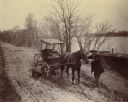
| Date: | 1898 |
|---|---|
| Description: | Horse-drawn carriage stuck in a rut on a muddy road near the Ohio River in Floyd County, Indiana. One man is holding the horse while another attempts to di... |
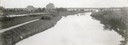
| Date: | 1908 |
|---|---|
| Description: | The Yahara River from Williamson Street with Lake Monona in the background. House & Barn pictured is located at 601 Riverside Drive. |

| Date: | 1870 |
|---|---|
| Description: | This bird's-eye-view map shows roads, a river with boats, and homes. The bottom margin of the map includes an index. |

| Date: | 1874 |
|---|---|
| Description: | This map shows lakes, rivers, state, county, and town boundaries, as well as railroads completed, in progress, and contemplated. The map includes a color d... |
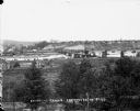
| Date: | |
|---|---|
| Description: | Elevated view from south side of the Chippewa River, with a bridge crossing it and buildings on both sides of the river. A bluff rises on the far side of t... |

| Date: | 1873 |
|---|---|
| Description: | Map of the township of Windsor, from the "Atlas of Dane County." |

| Date: | 1853 |
|---|---|
| Description: | Bird's-eye map of Milwaukee looking east toward Lake Michigan from a bluff, long since graded into a slope, at about 6th Street between Wisconsin Avenue an... |
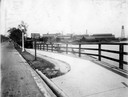
| Date: | 1919 |
|---|---|
| Description: | Deering Works factory seen across the waterfront from Diversey Avenue. In the foreground is a street and sidewalk with the sign "horse vehicles keep to rig... |
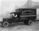
| Date: | 07 05 1927 |
|---|---|
| Description: | Driver in an International delivery truck parked along the waterfront with the Queensboro Bridge in the background. The truck was owned by Joseph Victori &... |

| Date: | 1876 |
|---|---|
| Description: | Bird's-eye view of Black Earth. |

| Date: | 1867 |
|---|---|
| Description: | Birds-eye drawing of Appleton, Outagamie Co., depicting street names and street layout, houses, the Fox River, the court house, jail, school houses, Lawren... |

| Date: | 05 31 1965 |
|---|---|
| Description: | Elevated view of Evangelical United Brethren church in the vicinity of Highway T. |

| Date: | 1910 |
|---|---|
| Description: | Map of Dane County rural delivery in Madison and the town of Westport. |

| Date: | 1832 |
|---|---|
| Description: | Hand-drawn map in two parts of the route of Governor J.D. Doty. Probably made by Doty in 1832 as a result of his travels with Alexander J. Center. |

| Date: | 1870 |
|---|---|
| Description: | Baraboo was first settled around 1838, and by 1870 it had become the county seat and the thriving village illustrated here. This birds eye drawing depicts ... |

| Date: | 1867 |
|---|---|
| Description: | Birds-eye drawing of Beaver Dam, Dodge Co., depicting street names and street layout, houses, rivers, lakes, and trees. A reference key at the bottom of th... |

| Date: | 1890 |
|---|---|
| Description: | Bird's-eye map of Beloit with insets of Williams Engine Works, Eclipse Wind Engine Co., and John Foster & Co. Turtle Creek is in the lower section, and the... |

| Date: | 1869 |
|---|---|
| Description: | Birds-eye drawing of Boscobel, Grant County, depicts street names and street layouts, houses, rivers and trees. A reference key at the bottom of the map sh... |
If you didn't find the material you searched for, our Library Reference Staff can help.
Call our reference desk at 608-264-6535 or email us at:
