 Filter: Categories of Wisconsin Historical Images
Filter: Subject of Roads
Filter: Subject of real estate business
Filter: Categories of Wisconsin Historical Images
Filter: Subject of Roads
Filter: Subject of real estate business
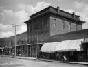
| Date: | 1900 |
|---|---|
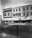
| Description: | Looking east across Pine Street at the F. A. Schwaller Music Store / Schwaller's Real Estate Office, flanked by Theodore Riel's dry goods and grocery store... |
| Date: | 1900 |
|---|---|
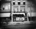
| Description: | Looking east across Pine Street at Jacob Black's dry goods store, with a display of hand fans in front window; Schwaller's Real Estate company is above Bla... |
| Date: | 1900 |
|---|---|
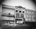
| Description: | Looking east across Pine street at the storefronts of J. Wien's clothing, dry goods, and grocery store, Black's Dry Goods store, Schwaller's Real Estate Of... |
| Date: | |
|---|---|
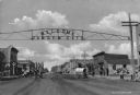
| Description: | View down Main Street with overhead sign reading "Welcome Garden City" sign. Text on buildings reads: "E.J. Pyle Real Estate" and "F. Finnup. Hardware." Ci... |

| Date: | 1911 |
|---|---|
| Description: | View of the West side of the town square, with automobiles, horse-drawn carts, pedestrians and a fountain. The street is lined with storefronts including "... |
| Date: | 1911 |
|---|---|
| Description: | View from street toward the Masonic building (erected 1876). Business signs read: (obscured) "Millinery," "W.F. Terrell," "M.J. Eves Real Estate & Insuranc... |
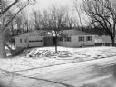
| Date: | 03 15 1954 |
|---|---|
| Description: | Advertisement for an open house at a newly-built house at 4137 Council Crest, Nakoma. The house was built by Harold E. Bewick, building contractor, and adv... |

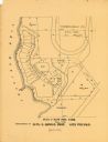
| Date: | 1903 |
|---|---|
| Description: | This map of Richland County, Wisconsin, shows land ownership and acreages, the township and range grid, sections, cities, towns and post offices, roads, ra... |
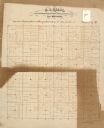
| Date: | |
|---|---|
| Description: | This 19th century manuscript map of the Town of Viroqua, Vernon County, Wisconsin, is drawn on a printed township grid. It shows landownership, roads, and ... |

| Date: | |
|---|---|
| Description: | Map shows roads, railroads, rivers, and improved farms. Includes text on lands for sale and exchange by B.W. Pulling, successor to Marshfield Land Company.... |

| Date: | 1910 |
|---|---|
| Description: | Shows land for sale by Rusk Farm Co. in Rusk and Chippewa Counties, as well as farmhouses, roads, and railroads. |

| Date: | 1891 |
|---|---|
| Description: | Map of a proposed subdivision. Map reads: "United States Investment Association SUBDIVISION No. 1 In S.W. 1/4 Sec. 33, Town 8, Range 22 East. Is situated a... |
| Date: | 1900 |
|---|---|
| Description: | This maps shows part of Galesville, Trempealeau County, Wisconsin. The map shows lots for sale, local streets, and part of Lake Marinuka. Lots are numbered... |

| Date: | 1920 |
|---|---|
| Description: | This map shows lands owned by the American Immigration Company (red) and the Homeseekers Land Company (green). The map also shows highways, roads, railroad... |

| Date: | 1915 |
|---|---|
| Description: | This map shows roads, railroads, street railways, abandoned logging railroads, rural mail routes, telephone lines, schools, platted land, and state forest ... |
If you didn't find the material you searched for, our Library Reference Staff can help.
Call our reference desk at 608-264-6535 or email us at: