 Filter: Categories of Wisconsin Historical Images
Filter: Subject of Roads
Filter: Subject of portraits
Filter: Categories of Wisconsin Historical Images
Filter: Subject of Roads
Filter: Subject of portraits
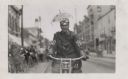
| Date: | |
|---|---|
| Description: | A man on his motorcycle in the street is posing with a small umbrella attached to his helmet. A watch also hangs from the front of his shirt. |

| Date: | |
|---|---|
| Description: | This 1907 map of Outagamie County, Wisconsin, shows the township and range grid, towns, sections, cities and villages, railroads, wagon roads, churches, sc... |

| Date: | 1860 |
|---|---|
| Description: | This map of Dodge County, Wisconsin, shows the township and range grid, towns, sections, cities and villages, railroads, roads, property owners and acreage... |

| Date: | 1835 |
|---|---|
| Description: | Shows Walker’s Point, Juneau Town and Kilbourn Town, including labeled buildings, trails and Indian villages. Relief shown by hachures. Oriented with north... |

| Date: | 1919 |
|---|---|
| Description: | View of a roadside hotel, with an inset portrait of the proprietor at the top left. Automobiles are in the parking lot. Caption reads: "Silver Lake Hotel, ... |
If you didn't find the material you searched for, our Library Reference Staff can help.
Call our reference desk at 608-264-6535 or email us at: