Filter: Categories of Wisconsin Historical Images
Filter: Subject of Roads
Filter: Subject of ponds
Filter: Categories of Wisconsin Historical Images
Filter: Subject of Roads
Filter: Subject of ponds

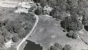
| Date: | 1964 |
|---|---|
| Description: | Aerial view of the Milwaukee County Zoo grounds nearing its completion. |

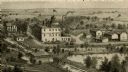
| Date: | 1879 |
|---|---|
| Description: | Bird's-eye view of Viroqua, county seat of Vernon County. |
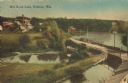
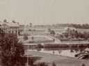
| Date: | 1905 |
|---|---|
| Description: | Elevated view of a pond, a stream, and a lake, with a road dividing the pond and stream from the lake. Industrial buildings and a smokestack are in the bac... |
| Date: | |
|---|---|
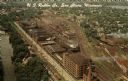
| Description: | Aerial view of the plant, with railroad tracks along both sides of the property. A river is on the left. Several cars are parked at the plant. There is an... |
| Date: | |
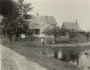
|---|---|
| Description: | Elevated view of barn and farmer's house of John Bass. |
| Date: | |
|---|---|
| Description: | An engraving based on a drawing by Alexander Simplot of the Platteville Brewery (spelled Plattville). It is an elevated perspective showing the main buildi... |

| Date: | 1900 |
|---|---|
| Description: | Elevated view of parade turning from Nebraska Street onto Main Street. Women with umbrellas line the sidewalk in the foreground of the image. The Montello ... |

| Date: | |
|---|---|
| Description: | View of a dirt bicycle path running alongside a small pond, with scattered trees. |
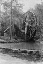
| Date: | |
|---|---|
| Description: | View from road with a stone wall toward a small stone building housing a grist mill, with a large water wheel on the right side. Surrounding the grist mill... |
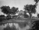
| Date: | 1911 |
|---|---|
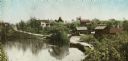
| Description: | A view of a roadside pond, with several buildings and trees in the background. |

| Date: | 1920 |
|---|---|
| Description: | Elevated view of a pond in the foreground, and the seashore beyond. Houses are along the cliffs in the background. |

| Date: | 1866 |
|---|---|
| Description: | View of earthworks at the battlefield at Resacca. Dirt roads cross the field in the distance, leading to a farm and what appears to be a river. Plate 22... |

| Date: | 10 1884 |
|---|---|
| Description: | Sanborn insurance map of Black River Falls covering the area bordered by the Black River on the East, 3rd Street on the West, Johnson Street on the North, ... |
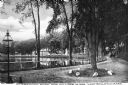
| Date: | 1899 |
|---|---|
| Description: | A man steers a horse and carriage down a winding country road near Clarendon Pond. Village dwellings are visible across the pond. |
| Date: | 09 09 1922 |
|---|---|
| Description: | The farmhouse of the Wetherby Cranberry Company. At the time the farmhouse was owned by H. Kissinger. In the foreground is the corner of the water reservoi... |
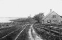
| Date: | |
|---|---|
| Description: | View of a cottage separated from Oyster Pond by fences and an unpaved road. |
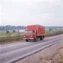
| Date: | 1972 |
|---|---|
| Description: | Color photograph of a man driving an International truck past a body of water in what appears to be a golf course. |
If you didn't find the material you searched for, our Library Reference Staff can help.
Call our reference desk at 608-264-6535 or email us at: