Filter: Categories of Wisconsin Historical Images
Filter: Subject of Roads
Filter: Subject of housing
Filter: Categories of Wisconsin Historical Images
Filter: Subject of Roads
Filter: Subject of housing
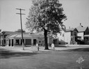
| Date: | 1940 |
|---|---|
| Description: | Commercial building with road (Broad Street) in foreground. Cars are parked in the lot, with Village Hall and residences in the background. |

| Date: | 06 07 1954 |
|---|---|
| Description: | Aerial view of the Midvale neighborhood under construction showing the intersection of Midvale and Tokay Boulevards near the southwestern city limits of Ma... |
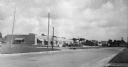
| Date: | 07 05 1965 |
|---|---|
| Description: | Street corner with gasoline station, 7-Up sign in front of restaurant next door, and several storefronts across the street. |
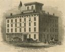
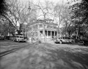
| Date: | 1853 |
|---|---|
| Description: | Illustration of the Capital house, a first-class hotel, copied from page 320 of Gleason's Pictorial Drawing-Room Companion. |

| Date: | 03 04 1937 |
|---|---|
| Description: | Eugene and Beth Coombs house, 212 Lakewood Boulevard, Lakewood, showing attached garage. |
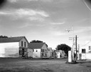
| Date: | 08 01 1929 |
|---|---|
| Description: | K-D Texaco Super Service Station, 521 E. Washington Avenue at S. Blair Street. The business was owned by Carl A. Kessenich and Ernest J. Dupuis. |
| Date: | 05 15 1926 |
|---|---|
| Description: | Phi Gamma Delta fraternity house, located at 521 North Henry Street, with Royal Rapid Transit Co. buses. |
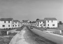
| Date: | 1936 |
|---|---|
| Description: | View down road of mass-produced residential housing with farm in background. |
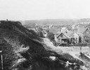
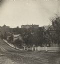
| Date: | 1925 |
|---|---|
| Description: | Elevated view from a hill of an alley connecting Park Hill Avenue and Mount Vernon Avenue, looking west from the Interurban Line. There is a person on top ... |
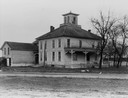
| Date: | 1935 |
|---|---|
| Description: | An old house in a rural area, with some broken windows, and a road in the foreground. |
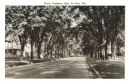
| Date: | 1930 |
|---|---|
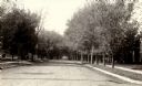
| Description: | View of residential street with many trees lining the terrace. Rails, possibly trolley rails, run down the center of the street. Caption reads: "North Broa... |
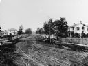
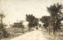
| Date: | 1870 |
|---|---|
| Description: | View of dirt road with houses along both sides, and wooden walkways and picket fences along the road. |

| Date: | |
|---|---|
| Description: | View down a curving residential, tree-lined street. Trolley tracks run the length of the street. |

| Date: | 10 10 1971 |
|---|---|
| Description: | Two houses at 1112 and 1114 Regent Street, both of which lean to one side. |
| Date: | |
|---|---|
| Description: | View of fence-lined Pinckney Street from Gilman Street including the Burrows House. |
| Date: | 1900 |
|---|---|
| Description: | A view of the southwest road heading into Sullivan. |

| Date: | 1907 |
|---|---|
| Description: | Elevated view of town. Caption reads: "Marshfield, Wisconsin". |

| Date: | 1907 |
|---|---|
| Description: | Elevated view of Marshfield. Caption reads: "Birdseye View of Marshfield, Wisconsin". |

| Date: | 1910 |
|---|---|
| Description: | An elevated view of town. Caption reads: "Bird's Eye View, Marshfield, Wis." |
If you didn't find the material you searched for, our Library Reference Staff can help.
Call our reference desk at 608-264-6535 or email us at: