 Filter: Categories of Wisconsin Historical Images
Filter: Subject of Roads
Filter: Subject of gardens
Filter: Categories of Wisconsin Historical Images
Filter: Subject of Roads
Filter: Subject of gardens
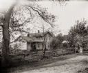
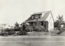
| Date: | 1900 |
|---|---|
| Description: | View from road towards a man standing on the porch of a home belonging to either Mrs. Kelly or Mrs. Stevenson. A fence runs along the road in front of the ... |
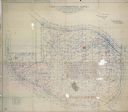
| Date: | 04 22 1915 |
|---|---|
| Description: | Topographical survey of a McCormick family property in Lake Forest, Illinois. The survey was completed for Anita McCormick [Mrs. Emmons] Blaine. The survey... |

| Date: | |
|---|---|
| Description: | A view of Hemlock Drive, bordered by a fence on both sides, entering the botanical gardens. |

| Date: | |
|---|---|
| Description: | Elevated exterior view of the girls' training home and gardens at the American Friends (Quaker) Mission. Girls appear to be hanging laundry on a line in th... |
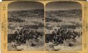
| Date: | |
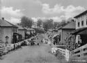
|---|---|
| Description: | Children and adults stand in an unpaved rural street lined with homes in a company town of Consolidated Coal Company. |
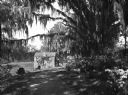
| Date: | |
|---|---|
| Description: | View of a brick cottage with ivy in a clearing as seen from a small dirt road through the woods. The road is bordered by flowering azalea bushes and the Sp... |
| Date: | 09 1925 |
|---|---|
| Description: | View from street of a small suburban residence with garden. |
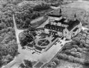
| Date: | 1950 |
|---|---|
| Description: | An aerial view of the monastery, showing a complex of buildings, roads, and the surrounding tree-covered property. A walled garden is between the entrance ... |
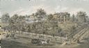
| Date: | 1872 |
|---|---|
| Description: | Lithograph elevated view of the Alexander Mitchell home and gardens seen from the corner of Ninth and Spring Streets. Pedestrians, horse-riders and a horse... |
| Date: | 1893 |
|---|---|
| Description: | A replication of the crucifixion of Jesus Christ. Depicted is the Damascus Road and the garden of Joseph of Arimathea. Joseph of Arimathea was a wealthy ma... |

| Date: | |
|---|---|
| Description: | View from road of the exterior of the creamery. The main building features a gable roof, a cupola, two chimneys, as well as a garden in front. There are th... |
| Date: | |
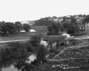
|---|---|
| Description: | Elevated view of a stream with a dam and a bridge. There is a small fenced garden along the water. In the distance is a hillside with houses. |

| Date: | 1897 |
|---|---|
| Description: | Topographical map of Stanley McCormick's Riven Rock estate in El Montecito, Santa Barbara County, California. The map is identified as a map of a survey co... |
| Date: | 1931 |
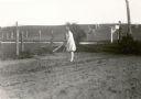
|---|---|
| Description: | Lorena Feldmann, 13, hoes in the garden at her family's farm. She is somewhat overdressed for the task in a light coat, white stockings and dress shoes. A ... |

| Date: | 1927 |
|---|---|
| Description: | The grounds at Springhill Cottages, with four cottages on the hill in the background. There is a person sitting on a chair inside an open-sided building in... |

| Date: | 1956 |
|---|---|
| Description: | This map shows Lake Wisconsin, roads, highways, parks, resort areas, camps, gardens, and Wisconsin State experimental game and fur farm. The back of the ma... |

| Date: | 1900 |
|---|---|
| Description: | View from a wooden plank walkway across a dirt road towards sculpted gardens. Large buildings are in the background behind trees. |

| Date: | |
|---|---|
| Description: | V across driveway towards a lawn with manicured bushes. Identified as the Spaulding lawn, with a well-manicured yard with sculpted shrubs. |

| Date: | |
|---|---|
| Description: | Outdoor group portrait of a family at their farm. The family is posing on the far right in the yard. On the left near the house is a windmill with a sign f... |

| Date: | 1930 |
|---|---|
| Description: | A map of the site of a Native American village with a complex of linear raised garden beds and cache pits near Leeman. Also shown are a farmstead, road, an... |
If you didn't find the material you searched for, our Library Reference Staff can help.
Call our reference desk at 608-264-6535 or email us at: