Filter: Categories of Wisconsin Historical Images
Filter: Subject of Roads
Filter: Subject of cities and towns
Filter: Categories of Wisconsin Historical Images
Filter: Subject of Roads
Filter: Subject of cities and towns

| Date: | 1870 |
|---|---|
| Description: | This bird's-eye-view map shows roads, a river with boats, and homes. The bottom margin of the map includes an index. |
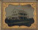
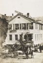
| Date: | 1858 |
|---|---|
| Description: | Ambrotype of the Wade House, a carriage inn located in Greenbush, also showing a section of the original plank road in the foreground. |
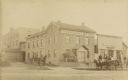
| Date: | 1885 |
|---|---|
| Description: | Exterior view of Fauerbach's Brewery at 651-53 Williamson Street. |
| Date: | 07 24 1934 |
|---|---|
| Description: | View looking east from Monroe Street, down the newly widened and paved Regent Street. Businesses include Castle and Doyle building supplies on the left (15... |
| Date: | 1954 |
|---|---|
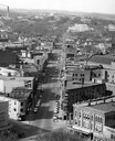
| Description: | Elevated view of State Street looking toward Bascom Hall and the University of Wisconsin-Madison campus from the Wisconsin State Capitol dome. |

| Date: | 08 28 1970 |
|---|---|
| Description: | An aerial view of West Towne Shopping Center (now West Towne Mall) at Mineral Point and Gammon Roads. |

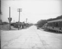
| Date: | 1906 |
|---|---|
| Description: | State Street with torn up streetcar lines, looking east from Park Street. |
| Date: | |
|---|---|
| Description: | Elevated view of Kleinstueber's Machine Shop, where Christopher Latham Sholes perfected his typewriter. The sign on the top of the building reads: "Brass F... |

| Date: | 01 1934 |
|---|---|
| Description: | Aerial view of New Butler, in Waukesha County. |
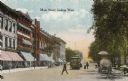
| Date: | 1900 |
|---|---|
| Description: | View down Main Street on the Capitol Square. Caption reads: "Main Street, looking West." |
| Date: | 1910 |
|---|---|
| Description: | Looking west down wooden sidewalk along La Pointe's unpaved main street. |

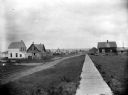
| Date: | 1910 |
|---|---|
| Description: | View of La Pointe taken from Big Bay Road on Madeline Island. |
| Date: | 1934 |
|---|---|
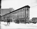
| Description: | Exterior view of the Sherlock Hotel, 124 King Street at the corner of Doty Street. Snow is on the ground. |

| Date: | 1886 |
|---|---|
| Description: | Bird's-eye view of Ashland, on the shores of Lake Superior, with insets of The Apostle Islands Chequamagon Bay & Ashland, and Distances from Ashland. |
| Date: | 1901 |
|---|---|
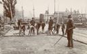
| Description: | A crew of construction workers paving North Main Street with brick. |

| Date: | 1874 |
|---|---|
| Description: | This map shows lakes, rivers, state, county, and town boundaries, as well as railroads completed, in progress, and contemplated. The map includes a color d... |
| Date: | 02 05 1930 |
|---|---|
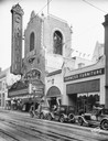
| Description: | View from across the street of the Capitol Theatre tower. "Love Parade" is advertised on the marquee. Three automobiles are in the street in front of Peopl... |
| Date: | 1922 |
|---|---|
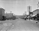
| Description: | View down main street with storefronts on both sides, with large power lines along the sidewalks stretching into the distance, and a hill in the background... |
| Date: | 1921 |
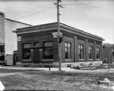
|---|---|
| Description: | Exterior view of the Bank of La Farge from street. |
If you didn't find the material you searched for, our Library Reference Staff can help.
Call our reference desk at 608-264-6535 or email us at: