 Filter: Categories of Wisconsin Historical Images
Filter: Subject of Roads
Filter: Subject of capitols
Filter: Categories of Wisconsin Historical Images
Filter: Subject of Roads
Filter: Subject of capitols
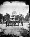
| Date: | 1876 |
|---|---|
| Description: | Issued as a stereograph on green mount entitled "The Artist." Two men stand by a wagon on which is written "A.L. Dahl Landscape Photographer." The flag on... |
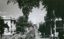
| Date: | 1971 |
|---|---|
| Description: | View of State Street looking east towards the Wisconsin State Capitol from Bascom Hill (on the University of Wisconsin-Madison campus). The Wisconsin Histo... |

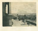
| Date: | |
|---|---|
| Description: | Elevated view, probably taken from the old Wisconsin State Capitol building, looking down East Washington Avenue toward the water tower. |

| Date: | |
|---|---|
| Description: | Elevated view, probably from the old Wisconsin State Capitol building, looking west down State Street. |
| Date: | 1864 |
|---|---|
| Description: | View down capitol building steps, where cannons sit on a landing, and statues decorate two lampposts. The city spreads out far below. Plate 03 |

| Date: | 1853 |
|---|---|
| Description: | Wisconsin counties by color and shows railroads, common roads, canals, the state capital, county towns, townships, villages, and post offices, |

| Date: | 1854 |
|---|---|
| Description: | Map of the whole state Wisconsin includes an inset of the vicinity of Milwaukee, which shows the boundaries for Lisbon, Menomonee, Pewaukee, Brookfield, Wa... |

| Date: | 1930 |
|---|---|
| Description: | This map features a legend of highways, railroads, parks, and service stations. The cover and inside of the map features pictures of attractions in Madison... |

| Date: | 1926 |
|---|---|
| Description: | This map is oriented with the north to the upper right and shows a plat of the area, numbered blocks, lots, and wards, land ownership by name, local street... |

| Date: | 1906 |
|---|---|
| Description: | This map shows shows streets, subdivisions, railroads, places of interest including the State Capitol, the University of Wisconsin, Camp Randall, Henry Vil... |

| Date: | 1924 |
|---|---|
| Description: | Intended for tourists, this brochure, titled: "Plan Now to See Madison, The Four Lake City: "The City Built on an Isthmus," features a map of Madison and s... |
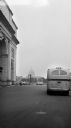
| Date: | 1950 |
|---|---|
| Description: | View from street towards the United States Capitol building. Several buses drive along the street with parked cars in a parking lot on the left. |

| Date: | 1914 |
|---|---|
| Description: | This map shows a plat of the town, city limits, numbered blocks and lots, wards, local streets, roads, railroads, Capitol Square, Vilas Park, Edgewood Acad... |

| Date: | 1938 |
|---|---|
| Description: | This map is blue line print and shows local streets, roads, the University of Wisconsin, Monona Village, Verona, Middleton, McFarland, Lake Mendota, Lake M... |
If you didn't find the material you searched for, our Library Reference Staff can help.
Call our reference desk at 608-264-6535 or email us at:
