 Filter: Categories of Wisconsin Historical Images
Filter: Subject of Roads
Filter: Subject of camping
Filter: Categories of Wisconsin Historical Images
Filter: Subject of Roads
Filter: Subject of camping
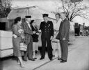
| Date: | 05 1959 |
|---|---|
| Description: | Trailer Convention Officials, including the Mayor and the Police Chief, standing outside near an Airstreamer. |
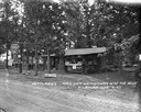
| Date: | |
|---|---|
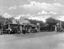
| Description: | A small gasoline station and refreshment station advertising distilled water, hot dogs, hamburgers, groceries, coffee, and other products. Near the station... |
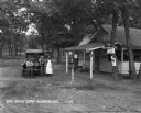
| Date: | |
|---|---|
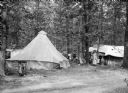
| Description: | Several women and children wearing dresses or swimming suits gather around two tents set up in a wooded area. A dirt road passes through the foreground. |
| Date: | 1925 |
|---|---|
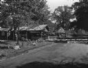
| Description: | An information station advertising: free camping, with hot sandwiches and coffee, and tents and cots for sale. On a utility line pole, there are signs for ... |

| Date: | 1968 |
|---|---|
| Description: | The map shows fire towers, public camp grounds, roads, snow mobile & riding trails, trout lakes, foot trails, railroads, and National Forest boundaries. |

| Date: | 1958 |
|---|---|
| Description: | Includes images of Flambeau River State Forest and a description of, canoeing and recreational activities in, and general park and forest information about... |
| Date: | 1929 |
|---|---|
| Description: | A man, woman, and child pose by a car near a tourist camping stop. |
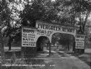
| Date: | 1929 |
|---|---|
| Description: | The entrance way to the Evergreen Resort. The sign advertises rooms, hot and cold water baths, meals, camp sites, and tourist kitchens. Caption reads: "Eve... |

| Date: | 1990 |
|---|---|
| Description: | A tourist map of Lafayette County, Wisconsin, that shows the locations of motels, camping, municipal parks, cheese factory tours, waysides, and golf course... |

| Date: | 1923 |
|---|---|
| Description: | This topographical map of Devil's Lake State Park, Sauk County, Wisconsin, is based on 1922-1923 surveys of the area by the University of Wisconsin Summer ... |
| Date: | 1925 |
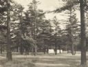
|---|---|
| Description: | Stand of pine trees and pitched tents, with automobiles, in the Marinette Tourist Camp. |

| Date: | 1932 |
|---|---|
| Description: | This map of Superior shows many points of interests including camping, fair grounds, docks, tourist attractions, lakes, roads, and waterways. |

| Date: | 1971 |
|---|---|
| Description: | This map of Nelson Dewey State Park shows the park layout, points of interest, facilities, campgrounds, roads, railroads, and the Mississippi River. Relief... |
| Date: | 1927 |
|---|---|
| Description: | View across road towards the main office at Nettland's Roll Inn. The building is of chink log construction with the round logs overlapping at the ends. Can... |

| Date: | 1977 |
|---|---|
| Description: | View up embankment towards Scout pulling a camper on a mountain road. |

| Date: | 1962 |
|---|---|
| Description: | This map shows roads, golf courses, ski areas, boat landings, camp sites, waysides, parks, beaches, scenic views, virgin timber tracts, airports, boys and ... |

| Date: | 1980 |
|---|---|
| Description: | This map shows the locations of 42 businesses, roads, points of interest, recreation sites, camping, the North Country Trail and parking, and boundaries of... |
| Date: | 1923 |
|---|---|
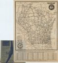
| Description: | This map shows road surfacing, cities, rivers, towns, roads, highways, and camp sites. Included are portions of Minnesota, Iowa, Illinois, and Michigan. La... |

| Date: | 1960 |
|---|---|
| Description: | This pictorial map shows recreation activities, rivers, lakes, and the history of the area. The map covers Langlade County and parts of adjacent counties. ... |

| Date: | 2000 |
|---|---|
| Description: | This map shows Wisconsin Public Service Corporation property, special regulation areas, public boat landings, roads, parks, and other recreation areas. Ins... |
If you didn't find the material you searched for, our Library Reference Staff can help.
Call our reference desk at 608-264-6535 or email us at: