Visit our other Wisconsin Historical Society websites!
 Filter: Categories of Wisconsin Historical Images
Filter: Subject of Roads
Filter: Subject of bridges
Filter: Categories of Wisconsin Historical Images
Filter: Subject of Roads
Filter: Subject of bridges
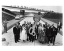
| Date: | 09 04 1958 |
|---|---|
| Description: | Dedication of Wisconsin's first expressway, a seven-mile stretch of Interstate Highway I-94 in Waukesha County, Wisconsin. Presiding at the ribbon-cutting ... |

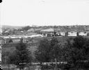
| Date: | 01 1934 |
|---|---|
| Description: | Aerial view of New Butler, in Waukesha County. |
| Date: | |
|---|---|
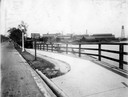
| Description: | Elevated view from south side of the Chippewa River, with a bridge crossing it and buildings on both sides of the river. A bluff rises on the far side of t... |

| Date: | 1856 |
|---|---|
| Description: | View looking west from Lake Michigan with several steam ships and sailing vessels in harbor. There is a lighthouse to left of center, along shoreline. |
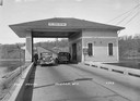
| Date: | 1937 |
|---|---|
| Description: | Toll House in Hudson showing two cars passing through. Caption reads: "Toll House, Hudson, Wis." |
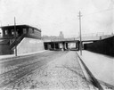
| Date: | 1912 |
|---|---|
| Description: | An empty street outside McCormick Station on the Illinois Northern Railway. An overpass bears a sign for the McCormick Freight Station on the same railroad... |
| Date: | 1919 |
|---|---|
| Description: | Deering Works factory seen across the waterfront from Diversey Avenue. In the foreground is a street and sidewalk with the sign "horse vehicles keep to rig... |
| Date: | |
|---|---|
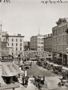
| Description: | Elevated view of Grand Avenue. A number of horse-drawn carriages are lined up near a bridge. |
| Date: | |
|---|---|
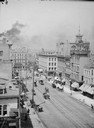
| Description: | Elevated view down Wisconsin from Broadway of buildings, street traffic and bridge in distance. |
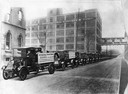
| Date: | 1920 |
|---|---|
| Description: | Long line of International trucks on a road next to International Harvester's Akron Works. Placards on the first two trucks read: "International motor truc... |
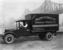
| Date: | 07 05 1927 |
|---|---|
| Description: | Driver in an International delivery truck parked along the waterfront with the Queensboro Bridge in the background. The truck was owned by Joseph Victori &... |

| Date: | 1867 |
|---|---|
| Description: | Birds-eye drawing of Appleton, Outagamie Co., depicting street names and street layout, houses, the Fox River, the court house, jail, school houses, Lawren... |

| Date: | 05 31 1965 |
|---|---|
| Description: | Elevated view of Evangelical United Brethren church in the vicinity of Highway T. |

| Date: | 1890 |
|---|---|
| Description: | Bird's-eye map of Beloit with insets of Williams Engine Works, Eclipse Wind Engine Co., and John Foster & Co. Turtle Creek is in the lower section, and the... |

| Date: | 1884 |
|---|---|
| Description: | Bird's-eye map of Delavan with inset of the State Institute for Deaf and Dumb. |

| Date: | 1867 |
|---|---|
| Description: | Bird's-eye map of La Crosse with nine insets of residences, schools, and the Court House and Jail. |

| Date: | 1882 |
|---|---|
| Description: | Bird's-eye views of various sections of Milwaukee. |
If you didn't find the material you searched for, our Library Reference Staff can help.
Call our reference desk at 608-264-6535 or email us at:


