 Filter: Categories of Wisconsin Historical Images
Filter: Subject of Roads
Filter: Subject of birds
Filter: Categories of Wisconsin Historical Images
Filter: Subject of Roads
Filter: Subject of birds

| Date: | 1870 |
|---|---|
| Description: | Bird's-eye view of Whitewater, with insets. |
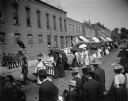
| Date: | 1902 |
|---|---|
| Description: | Women's Relief Corps with umbrellas parading down the street. Stuffed eagle parading as "Old Abe." Directly behind the two flags are, from left to right: ... |

| Date: | 1870 |
|---|---|
| Description: | Magazine illustration of the home, titled: "Soldiers' National Asylum at Milwaukee, Wisconsin". The building is in the background, and in the foreground ar... |
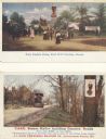
| Date: | |
|---|---|
| Description: | The eagle "Old Abe" was used for many years by J.I. Case Company, of Racine, Wisconsin, as the firm's trademark, and is shown on these advertising cards is... |
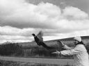
| Date: | 10 1981 |
|---|---|
| Description: | "Chuck Trauba releases pheasants on Warner Road." |

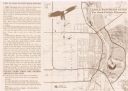
| Date: | 1936 |
|---|---|
| Description: | This pictorial tourist map from the Wisconsin Conservation Commission depicts vacation activities and identifies tourist destinations throughout the state.... |

| Date: | |
|---|---|
| Description: | On the far left a man and woman are posing sitting in a buggy pulled by a single horse. Next to them is a man posing sitting in a buggy pulled by a team of... |

| Date: | 1990 |
|---|---|
| Description: | Group of Brownie Girl Scouts and their leader are posing next to an International school bus at the Louisville zoo. In the background zookeepers and childr... |

| Date: | |
|---|---|
| Description: | A decorative map of Fuller's Woods development along the Lake Mendota shoreline. Includes numbered lots and building line setbacks with decorative features... |
| Date: | 1999 |
|---|---|
| Description: | This map shows the best places to view bald eagles and areas to avoid when watching for eagles. The back of the map includes text and illustrations. |

| Date: | 1952 |
|---|---|
| Description: | This map shows lakes, rivers, railroads, highways, roads, hunting grounds and trails around Flambeau Flowage and Boulder Junction in the north, to Brantwoo... |

| Date: | 1952 |
|---|---|
| Description: | This map shows hunting areas, lakes, rivers, railroads, highways, roads, and trails around Clam Lake, Glidden, and Flambeau Flowage in the north, to Hawkin... |

| Date: | 1966 |
|---|---|
| Description: | This map shows trails, roads, creeks, alleged location of George Gardner's trading post, Boulder and Mud Lakes, and a portion of the Wolf River. The map al... |

| Date: | |
|---|---|
| Description: | Map showing the location of the Little Bohemia lodge and restaurant, with major routes from Chicago and eastern and central Wisconsin. |
If you didn't find the material you searched for, our Library Reference Staff can help.
Call our reference desk at 608-264-6535 or email us at: