 Filter: Categories of Wisconsin Historical Images
Filter: Subject of Roads
Filter: Subject of bathing beaches
Filter: Categories of Wisconsin Historical Images
Filter: Subject of Roads
Filter: Subject of bathing beaches
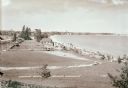
| Date: | 1936 |
|---|---|
| Description: | Elevated view of Crescent Beach, with campsite with cabins and miniature golf course and other outbuildings. Downtown buildings can be seen in the backgrou... |
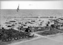
| Date: | 1920 |
|---|---|
| Description: | Elevated view of the Dipsy Baths outbuilding and surrounding beach. Umbrellas are set up in the sand where people sunbathe or wade in the water, and an Ame... |

| Date: | 1940 |
|---|---|
| Description: | Shows Milwaukee and Waukesha counties, and parts of Dodge, Washington, Ozaukee, Jefferson, Walworth, and Racine counties. Includes indexes of "Cities, Town... |

| Date: | 1932 |
|---|---|
| Description: | This map of Superior shows many points of interests including camping, fair grounds, docks, tourist attractions, lakes, roads, and waterways. |

| Date: | |
|---|---|
| Description: | A collection of images from Nettland's Roll Inn and other sites around the Dells including: the Narrows, Stand Rock, Lone Rock, and the beach at Lake Delto... |

| Date: | 1962 |
|---|---|
| Description: | This map shows roads, golf courses, ski areas, boat landings, camp sites, waysides, parks, beaches, scenic views, virgin timber tracts, airports, boys and ... |

| Date: | 1938 |
|---|---|
| Description: | This map shows roads, parks, golf courses, airports, beaches, docks and harbors, lighthouses, and buoys within Winnebago County and parts of Waushara, Calu... |

| Date: | 1960 |
|---|---|
| Description: | This map shows public boat ramps, parks, highways, beaches, bluffs, Green Bay, Garrett Bay, Europe Bay and Lake, Rowley's Bay and Ellison Bay. The map incl... |

| Date: | 1959 |
|---|---|
| Description: | This map shows public access sites, public beaches and parks, other public shorelines, boat liveries, public hunting and fishing grounds, railroads, roads,... |

| Date: | 1994 |
|---|---|
| Description: | This map shows historical sites, picnic grounds, public boat landings, canoe and motor boat trips, and resort locations. The left margin of the map include... |

| Date: | |
|---|---|
| Description: | Kodak photographic postcard of an aerial view of a lakeside resort with a large, sandy beach. Caption reads: "Phil's Lake Nokomis Resort, Heafford Junction... |
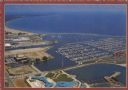
| Date: | 1975 |
|---|---|
| Description: | Text on reverse: "Magnificent view of Lake Michigan shoreline from Racine Harbor to Wind Point Lighthouse. Photo Courtesy RAMAC." Aerial view of Racine Har... |
If you didn't find the material you searched for, our Library Reference Staff can help.
Call our reference desk at 608-264-6535 or email us at: