 Filter: Categories of Wisconsin Historical Images
Filter: Subject of Roads
Filter: Subject of apostle islands
Filter: Categories of Wisconsin Historical Images
Filter: Subject of Roads
Filter: Subject of apostle islands

| Date: | 1886 |
|---|---|
| Description: | Bird's-eye view of Ashland, on the shores of Lake Superior, with insets of The Apostle Islands Chequamagon Bay & Ashland, and Distances from Ashland. |

| Date: | 1886 |
|---|---|
| Description: | Bird's-eye view of Bayfield, county seat of Bayfield County. On the lower left side is an inset for Bayfield and the Apostle Islands. |

| Date: | 1886 |
|---|---|
| Description: | Bird's-eye map of Washburn on Lake Superior. There is an inset of Washburn, Chequamagon and the Apostle Islands. |

| Date: | 1913 |
|---|---|
| Description: | A couple strolling down the main road, through the woods, to the mission on Madeline Island. |
| Date: | 1935 |
|---|---|
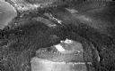
| Description: | Aerial view of Madeline Island including the tennis courts, houses, and the Old Mission Inn. |

| Date: | 1934 |
|---|---|
| Description: | Tree-lined dirt road curving along Madeline Island. |
| Date: | 1934 |
|---|---|
| Description: | Aerial view of Big Bay on Madeline Island. This area later became Big Bay State Park. |
| Date: | 1935 |
|---|---|
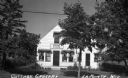
| Description: | View from road of Cottage Grocery store on Main Street on Madeline Island. |
| Date: | 1935 |
|---|---|
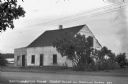
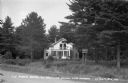
| Description: | White stucco house with wooden addition next to Lake Superior on Madeline Island. At the time of the photograph this was the oldest house on Madeline Islan... |
| Date: | 1938 |
|---|---|
| Description: | View from road of two-story white hotel with a screen porch; a sign advertising "The Pines" is attached onto two pine trees in front of the hotel. |
| Date: | 1937 |
|---|---|
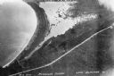
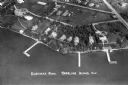
| Description: | Aerial view of Nebraska Row on the lakeshore of the west side of La Pointe, showing houses, roads and piers. Nebraska Row was started in 1899 when summer r... |

| Date: | 1884 |
|---|---|
| Description: | A detailed, hand-colored map of Wisconsin and the western portion of Michigan’s Upper Peninsula, which also includes an inset of Isle Royale in Lake Superi... |

| Date: | 1990 |
|---|---|
| Description: | This tourism brochure of Ashland County, Wisconsin, from the Ashland Area Chamber of Commerce includes a map of the county showing tourist destinations and... |
If you didn't find the material you searched for, our Library Reference Staff can help.
Call our reference desk at 608-264-6535 or email us at: