Filter: Categories of Wisconsin Historical Images
Filter: Subject of Roads
Filter: Subject of airports
Filter: Categories of Wisconsin Historical Images
Filter: Subject of Roads
Filter: Subject of airports
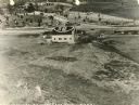
| Date: | 1923 |
|---|---|
| Description: | The entrance to the Larson Brothers' flying field at Larsen in Winnebago County, about one year after the brothers laid out the runway. The field remained... |

| Date: | 11 16 2001 |
|---|---|
| Description: | Aerial view of General Mitchell International in Milwaukee, looking southeast to the Lake Michigan shoreline. |
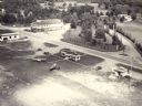
| Date: | 04 09 1931 |
|---|---|
| Description: | Aerial view of Lake Delton airport. |
| Date: | 1957 |
|---|---|
| Description: | Aerial view of the Baraboo Wisconsin Dells airport. |

| Date: | 1961 |
|---|---|
| Description: | Aerial view of a small settlement in the mountains, Luang Prabang vicinity, Laos. A narrow dirt road winds across the terrain and some buildings and an air... |

| Date: | 1961 |
|---|---|
| Description: | A woman carrying a basket on her back leads a mule laden with bundles across an airstrip at Keukacham village, Laos. There are 55-gallon drums near a tent,... |

| Date: | 1961 |
|---|---|
| Description: | Aerial view of Keukacham village, Laos including landing strip with helicopter. The small settlement is clearly visible contrasted against the verdant gree... |
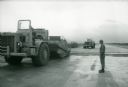
| Date: | 1967 |
|---|---|
| Description: | A man stands beside an International 270 pay scraper at Phan Rang, an air base in South Vietnam. |
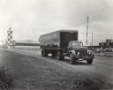
| Date: | 1944 |
|---|---|
| Description: | Man driving an International KR-11 truck with semi-trailer at the Billings Municipal Airport. The truck was operated by Northwest Freight Lines. Original c... |

| Date: | 1933 |
|---|---|
| Description: | A road map of Wisconsin and Michigan’s Upper Peninsula, showing the populations of cities and villages, state and federal highways, national forests, state... |

| Date: | 1950 |
|---|---|
| Description: | A map from the Wisconsin identifying the locations airports and other landing facilities in the state. On the opposite side the map includes an alphabetica... |

| Date: | 1939 |
|---|---|
| Description: | This nine-part map from the U.S. Bureau of Public Roads identifies federal and state highways in Wisconsin by pavement type. County, forest, park, and publ... |

| Date: | 1969 |
|---|---|
| Description: | This Post Office Department map identifies post offices, summer post offices, rural stations, highway post offices, Post Office sectional centers, rural de... |

| Date: | 1946 |
|---|---|
| Description: | A map showing the roads, railroads, towns, cities and villages, streams and lakes, airports, schools, churches, cemeteries, and golf courses in Kenosha Cou... |

| Date: | 02 1956 |
|---|---|
| Description: | This 1956 map of Waukesha County, Wisconsin, shows the township and range grid, towns, sections, cities and villages, roads, railroads, dams, airports, par... |

| Date: | 1987 |
|---|---|
| Description: | This 1987 map of Racine and Kenosha counties, Wisconsin, shows towns, sections, cities and villages, zip code boundaries, highways and roads, bicycle route... |

| Date: | 1900 |
|---|---|
| Description: | This map of Three Lakes shows forest fire lookout towers, picnic grounds, an airport, roads, and railroad. The map features text boxes on the Village of Th... |

| Date: | 1950 |
|---|---|
| Description: | This map shows portions of highway remaining unchanged, proposed relocations, connecting county trunk roads existing or proposed, existing arterials, and e... |

| Date: | 1962 |
|---|---|
| Description: | This map shows roads, golf courses, ski areas, boat landings, camp sites, waysides, parks, beaches, scenic views, virgin timber tracts, airports, boys and ... |
If you didn't find the material you searched for, our Library Reference Staff can help.
Call our reference desk at 608-264-6535 or email us at: