Filter: Categories of Wisconsin Historical Images
Filter: Subject of Roads
Filter: Subject of aerial photographs
Filter: Categories of Wisconsin Historical Images
Filter: Subject of Roads
Filter: Subject of aerial photographs

| Date: | 1958 |
|---|---|
| Description: | Aerial view of contour strip farming with the Obert Olstad farm in foreground. The Carl Backum farm is in the background. |

| Date: | 06 27 1927 |
|---|---|
| Description: | Aerial view of the effigy mound on Henry Wehmhoff's Riverview Farm. State Trunk Highway 83 runs through the effigy. |

| Date: | 1956 |
|---|---|
| Description: | Aerial view of the South Park Street interchange. |

| Date: | 08 28 1970 |
|---|---|
| Description: | An aerial view of West Towne Shopping Center (now West Towne Mall) at Mineral Point and Gammon Roads. |

| Date: | 01 1934 |
|---|---|
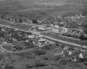
| Description: | Aerial view of New Butler, in Waukesha County. |

| Date: | 1908 |
|---|---|
| Description: | A panoramic aerial view of the Isthmus taken from a kite. Lake Mendota is to the right in the background with Picnic Point jutting into the lake. The photo... |

| Date: | 06 07 1954 |
|---|---|
| Description: | Aerial view of the Midvale neighborhood under construction showing the intersection of Midvale and Tokay Boulevards near the southwestern city limits of Ma... |

| Date: | 06 07 1954 |
|---|---|
| Description: | Aerial view looking north from near the city's southwestern limits in 1954. Shows text indicating Midvale Boulevard, Odana Road, Tokay Boulevard, Mineral P... |

| Date: | 1955 |
|---|---|
| Description: | Aerial view of Midvale neighborhood under construction near Madison's southwestern city limits. The view is focused on the area bounded by Tokay Boulevard,... |

| Date: | 1958 |
|---|---|
| Description: | Aerial view of Craig Avenue and Crestwood Avenue. |

| Date: | 1964 |
|---|---|
| Description: | Aerial view of the Milwaukee County Zoo grounds nearing its completion. |

| Date: | 05 09 1908 |
|---|---|
| Description: | Kite aerial panoramic photograph of the central business district. In the distance is Lake Mendota. The fire damaged Wisconsin State Capitol is in the cent... |

| Date: | 11 16 2001 |
|---|---|
| Description: | Aerial view of General Mitchell International in Milwaukee, looking southeast to the Lake Michigan shoreline. |
| Date: | 04 09 1931 |
|---|---|
| Description: | Aerial view of Lake Delton airport. |

| Date: | 1923 |
|---|---|
| Description: | Aerial view of the Wisconsin Historical Society, Science Hall, and Bascom Hall on Bascom Hill on the University of Wisconsin-Madison campus. Lake Mendota i... |
| Date: | 1947 |
|---|---|
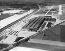
| Description: | Aerial view of International Harvester's Evansville Works factory complex. |
| Date: | 02 02 1954 |
|---|---|
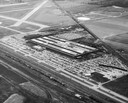
| Description: | Aerial view of International Harvester's Evansville Works factory complex. The Evansville Works produced refrigerators, freezers and air conditioners. |

| Date: | 1930 |
|---|---|
| Description: | Aerial view of the city and the river. |

| Date: | 1945 |
|---|---|
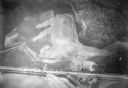
| Description: | Aerial view of the "powder storage area" of the Badger Ordnance Plant. |
If you didn't find the material you searched for, our Library Reference Staff can help.
Call our reference desk at 608-264-6535 or email us at: