Filter: Categories of Wisconsin Historical Images
Filter: Subject of Roads
Filter: County of Trempealeau
Filter: Categories of Wisconsin Historical Images
Filter: Subject of Roads
Filter: County of Trempealeau
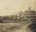
| Date: | 1875 |
|---|---|
| Description: | View across unpaved road towards a group of men standing on the platform at the train depot, with the Mineral Springs Hotel behind and to the right. Anothe... |
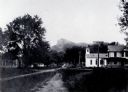
| Date: | 1890 |
|---|---|
| Description: | View across unpaved road towards the Blair House. Caption reads: "Blair House, The Travelingman's Home, Blair, Wis." |
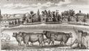
| Date: | 1877 |
|---|---|
| Description: | View of cattle, sheep, and pigs in a pasture on a farm. Two houses are in the distance, and a horse-drawn carriage is moving along the road on the left. Ca... |
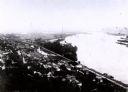
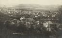
| Date: | 1907 |
|---|---|
| Description: | Elevated view from first peak of Trempealeau, Wisconsin. |
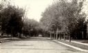
| Date: | 1907 |
|---|---|
| Description: | Fourth street in Trempealeau, Wisconsin. |
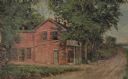
| Date: | 1931 |
|---|---|
| Description: | Drawing of the Melchoir House, which was a popular hostelry and brewery operated by Jacob Melchoir. It later became an Indian boarding house. |
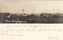
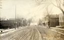
| Date: | 1905 |
|---|---|
| Description: | View down road towards the town. Hills are in the distance. Caption reads: "Strum Wis. from South". |
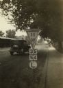
| Date: | 1925 |
|---|---|
| Description: | Wisconsin State Highway sign along STH 11 near Galesville, one of a whole new vocabulary of signage created for automobile traffic. The inverted triangle w... |
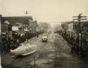
| Date: | 11 25 1919 |
|---|---|
| Description: | Submarine float for parade and bonfire celebrating Armistice Day. |

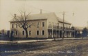
| Date: | 1925 |
|---|---|
| Description: | View from road of a two-story brick structure identified as the Melchior Hotel. See also image 67069. |
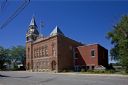
| Date: | 2009 |
|---|---|
| Description: | View of Independence Opera House, city hall, clock tower and public library building from across the street. |
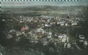
| Date: | 07 29 1909 |
|---|---|
| Description: | Aerial view of the downtown area, including a bridge spanning the Trempealeau River. Caption reads: "View of Arcadia, Wisconsin." |
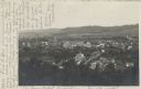
| Date: | 01 03 1914 |
|---|---|
| Description: | Elevated view of downtown and the Trempealeau River. Caption reads: "Bird's [sic] Eye View, Arcadia, Wis." |

| Date: | 10 17 1923 |
|---|---|
| Description: | Exterior view of the two-story brick High School building with basement. A bare flagpole can be seen on the roof. Caption reads: "High School, Arcadia, Wis... |
| Date: | 05 22 1906 |
|---|---|
| Description: | Aerial view of the city and rolling hills in the background. A bridge crossing the Trempealeau River is also visible. |

| Date: | 1877 |
|---|---|
| Description: | This 1877 map of Trempealeau County, Wisconsin, shows the township and range grid, sections, towns, cities and villages, land ownership and acreages, roads... |

| Date: | 1929 |
|---|---|
| Description: | This 1929 topographic map of Trempealeau County, Wisconsin, shows the topography, lakes, streams and wetlands, township and range grid, sections, cities an... |
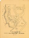
| Date: | 1900 |
|---|---|
| Description: | This maps shows part of Galesville, Trempealeau County, Wisconsin. The map shows lots for sale, local streets, and part of Lake Marinuka. Lots are numbered... |
If you didn't find the material you searched for, our Library Reference Staff can help.
Call our reference desk at 608-264-6535 or email us at: