Filter: Categories of Wisconsin Historical Images
Filter: Subject of Roads
Filter: County of Shawano
Filter: Categories of Wisconsin Historical Images
Filter: Subject of Roads
Filter: County of Shawano
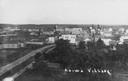
| Date: | 1910 |
|---|---|
| Description: | Elevated view of Aniwa. "Aniwa Village" is written on the photograph. |

| Date: | 1930 |
|---|---|
| Description: | Shawano County Highway Department garage. |

| Date: | 1910 |
|---|---|
| Description: | View down center of unpaved street. Caption reads: "Main St., Looking South, Shawano, Wis." |

| Date: | 1910 |
|---|---|
| Description: | Photographic postcard showing a man driving an early open automobile with a railroad overpass behind him. Caption reads: "Out for a Spin, Bonduel, Wis." |
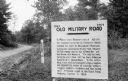
| Date: | 1924 |
|---|---|
| Description: | A sign north of Shawano marks the Military Road, built 1864-1871, from Green Bay, Wisconsin, to Marquette, Michigan. In 1924 the Wisconsin portion of the r... |

| Date: | |
|---|---|
| Description: | Photographic postcard view of the Hotel Carley. Two women are sitting on the far left steps of the hotel. One man is sitting in a chair near the entrance, ... |
| Date: | |
|---|---|
| Description: | Letterhead of Rural Route No. 3 in Bonduel, Wisconsin, with a man driving a U.S. R.F.D. mail wagon along a road by a fenced yard, a barn, and a mailbox. Pr... |

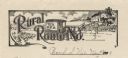
| Date: | 1920 |
|---|---|
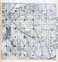
| Description: | This map shows the township and range system, sections, schools, churches, cemeteries, town halls, roads, railroads, and lakes and streams in Shawano Count... |

| Date: | 1933 |
|---|---|
| Description: | This map shows the township and range system, sections, cities and villages, schools, roads, railroads, and lakes and streams in Shawano County, which at t... |

| Date: | 1900 |
|---|---|
| Description: | Shows lands belonging to Wisconsin Timber and Land Co., towns, post offices, saw mills, creameries, camps, churches, schools, farm houses, town halls, rail... |
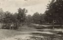
| Date: | 1925 |
|---|---|
| Description: | Photographic postcard view of a road passing through the county park. Caption reads: "Shawano County Park, Cecil, Wis." |

| Date: | 1963 |
|---|---|
| Description: | Rustic dirt road leading to a farm. Loose stone walls line both sides of the driveway, and a large tree is in the left foreground. |
If you didn't find the material you searched for, our Library Reference Staff can help.
Call our reference desk at 608-264-6535 or email us at: