 Filter: Categories of Wisconsin Historical Images
Filter: Subject of Roads
Filter: County of Sauk
Filter: Categories of Wisconsin Historical Images
Filter: Subject of Roads
Filter: County of Sauk
| Date: | 1950 |
|---|---|
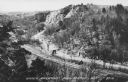
| Description: | Text on front reads: "Upper Narrows, Rock Springs, Wis." A road and a railroad tracks run next to each other in an elevated view of the Upper Narrows. Text... |
| Date: | 1950 |
|---|---|
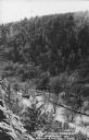
| Description: | Text on front reads: "The Old Mill Stream in the Narrows at Rock Springs, Wis." A road and the Narrows Creek run next to each other in an elevated view of ... |

| Date: | 08 14 1929 |
|---|---|
| Description: | Text on front reads: "Lovers Lane, Sauk City, Wis." An unpaved, rural road with a wooden guard rail on both sides. A sign reads: "Automobiles Go Slow." Beh... |

| Date: | 08 25 1911 |
|---|---|
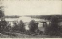
| Description: | Text on front reads: "Down River from Round Bluff, Prairie Du Sac, Wis." A view of the Wisconsin River with buildings and a road along the left shoreline. ... |

| Date: | 1950 |
|---|---|
| Description: | Text on front reads: "Wisconsin River Bridge, Spring Green, Wis." A truss bridge with eight spans over the Wisconsin River on State Highway 14. The bridge ... |

| Date: | 11 04 1912 |
|---|---|
| Description: | A horse-drawn buggy crossing a bridge with trees overhead. |
| Date: | 1950 |
|---|---|
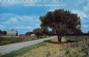
| Description: | Text on front reads: "Greetings from Spring Green, Wis." A country road curves to the left around a farm. On the right are a tree, fields and a fence with ... |
| Date: | 1950 |
|---|---|
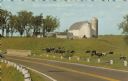
| Description: | Text on front reads: "Greetings from Spring Green." On the reverse it reads: "Grazing in Contentment." A herd of mostly Holstein cows in a pasture on the s... |
| Date: | 08 29 1913 |
|---|---|
| Description: | Text on front reads: "Wisconsin River Wagon Bridge, Spring Green, Wis." Elevated view of the bridge over the Wisconsin River on State Highway 23. It was de... |
| Date: | 1922 |
|---|---|
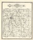
| Description: | A plat map by Westfield created by George A. Ogle & Co. |
| Date: | 1922 |
|---|---|
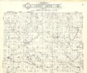
| Description: | A plat map of the Township of Honey Creek, created by Geo. A. Ogle & Co. |
If you didn't find the material you searched for, our Library Reference Staff can help.
Call our reference desk at 608-264-6535 or email us at: