 Filter: Categories of Wisconsin Historical Images
Filter: Subject of Roads
Filter: County of Sauk
Filter: Categories of Wisconsin Historical Images
Filter: Subject of Roads
Filter: County of Sauk
| Date: | |
|---|---|
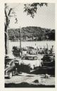
| Description: | Automobiles line up to wait for the Merrimac ferry "Colsac". |

| Date: | 1931 |
|---|---|
| Description: | View down driveway of the entrance sign to the Evergreen Retreat. In the background an automobile is parked near buildings and a flag on a flagpole. |

| Date: | 1922 |
|---|---|
| Description: | Children on the porch of a general store and filling station. The business advertises Polarine motor oil, Goodrich tires, Camel cigarettes, and Red Crown g... |

| Date: | 1944 |
|---|---|
| Description: | Motorcycle police at the Badger Ordnance plant in Baraboo, Wisconsin, between 1942 and 1945. These men patrolled the fence line of the plant. One of the gu... |

| Date: | 1877 |
|---|---|
| Description: | This 1877 map of Sauk County, Wisconsin, shows the township and range grid, sections, towns, cities and villages, land ownership and acreages, wagon roads,... |

| Date: | 1939 |
|---|---|
| Description: | This map of Sauk County, Wisconsin, shows the township and range grid, towns, sections, cities and villages, roads, railroads, lakes and rivers, schools, a... |

| Date: | 1990 |
|---|---|
| Description: | This late 20th century tourist map of Sauk County, Wisconsin, shows the highways and roads, cities and towns, parks, airports, canoe landings, hospitals, s... |

| Date: | 1920 |
|---|---|
| Description: | This map of Devil's Lake State Park in Sauk County, Wisconsin, shows the park limits, railroads, roads, creeks, trails, and points of interest in the area.... |

| Date: | 1923 |
|---|---|
| Description: | This topographical map of Devil's Lake State Park, Sauk County, Wisconsin, is based on 1922-1923 surveys of the area by the University of Wisconsin Summer ... |

| Date: | 1926 |
|---|---|
| Description: | Map showing Devil's Lake State Park limits, railroads, roads, creeks, trails, and park sites. Accompanying text about the location, natural features, attra... |

| Date: | 1915 |
|---|---|
| Description: | This 1915 map covers the section of the Wisconsin River in southern Adams, southeastern Juneau, northeastern Sauk, and northwestern Columbia counties. A po... |

| Date: | 1859 |
|---|---|
| Description: | Shows townships and sections, landownership, roads, railroads, rural residences, schools, churches, and topography. Relief shown by hachures. "From governm... |
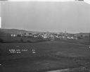
| Date: | 1921 |
|---|---|
| Description: | Elevated view over farm fields in the foreground and town in the distance, with low rolling hills in the far background. Buildings that stand out are St Lu... |
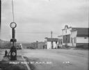
| Date: | 1929 |
|---|---|
| Description: | View from town of the road leading out of town towards fields and low hills. On the left at the curb is a fire hydrant and a Red Crown Gasoline gas pump. A... |

| Date: | |
|---|---|
| Description: | View from unpaved road of workers gathered in front of the brewery building, which has numerous chimneys, and one very tall chimney pipe. One of the men is... |

| Date: | 1931 |
|---|---|
| Description: | View from road of a man standing near his overturned car smoking a cigarette. His coat is lying across the side of the car. In the background is a barbed w... |
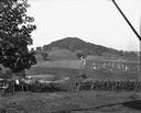
| Date: | 1928 |
|---|---|
| Description: | View down valley of a procession of hundreds of pilgrims walking up the hill to St. Anne's Chapel which is lined with Stations of the Cross. The crowd is w... |
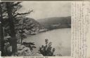
| Date: | 1906 |
|---|---|
| Description: | View from bluff of Devil's Lake. A road runs along the far shoreline. Caption reads: "Devil's Lake, Baraboo, Wis." |

| Date: | 1909 |
|---|---|
| Description: | Elevated view of the Baraboo River. The main part of town is on the far left shoreline. On the right industrial buildings are near a bridge spanning the ri... |
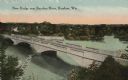
| Date: | 1919 |
|---|---|
| Description: | Colorized postcard of an elevated view of a concrete bridge over a river. There is a boat near wooden pilings that stretch from the shoreline to the center... |
If you didn't find the material you searched for, our Library Reference Staff can help.
Call our reference desk at 608-264-6535 or email us at: