Filter: Categories of Wisconsin Historical Images
Filter: Subject of Roads
Filter: County of Portage
Filter: Categories of Wisconsin Historical Images
Filter: Subject of Roads
Filter: County of Portage

| Date: | 1891 |
|---|---|
| Description: | Bird's-eye map of Stevens Point, looking east, with an inset of the Water Works. Wisconsin River in foreground with fifty-three business locations identifi... |
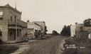
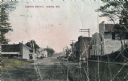
| Date: | 1905 |
|---|---|
| Description: | View down unpaved street with commercial buildings. Caption reads: "St. Scene, Bancroft, Wis." |

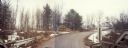
| Date: | 1965 |
|---|---|
| Description: | Aerial view of town and Highway 66. |
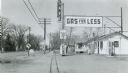
| Date: | 1958 |
|---|---|
| Description: | A gasoline station along US Highway 51 in Whiting, Portage County, attracted passing motorists with an attention-getting "gas for less" sign. |
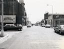
| Date: | 07 28 1970 |
|---|---|
| Description: | Traffic on Stevens Point's Second Street. |

| Date: | 05 21 1968 |
|---|---|
| Description: | Rural tavern and gasoline station on STH 54. |

| Date: | 1910 |
|---|---|
| Description: | View down the avenue, with an automobile approaching. Caption reads: "Strong Ave., looking South, Stevens Point, Wis." |

| Date: | 1900 |
|---|---|
| Description: | View across road towards the church. Caption reads: "St. Peter's Polish Catholic church, Steven's Point, Wis." |
| Date: | 1965 |
|---|---|
| Description: | Aerial view, looking west, with potato warehouses in the foreground and a pallet factory and junkyard behind them at right. |

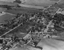
| Date: | 1965 |
|---|---|
| Description: | Aerial view looking north-northwest. View includes houses, roads, farm buildings, tractor-trailors (parked), other buildings. |
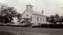
| Date: | 1968 |
|---|---|
| Description: | View across road towards the Buena Vista United Methodist Church. A row of cars are parked in front. |

| Date: | |
|---|---|
| Description: | Exterior view from road of the Stevens Point Public Library. The library opened in 1904 and was funded by a $22,000 donation from Andrew Carnegie. Above th... |

| Date: | |
|---|---|
| Description: | View of Saint Stanislaus Kostka Catholic Church, completed in 1918. A staircase leads to the main entrance of the brick building with a belfry. |
| Date: | |
|---|---|
| Description: | Color photographic postcard of the business district. Local business and homes are on on both sides of the main road. Horse-drawn wagons are parked on the ... |

| Date: | 08 24 1967 |
|---|---|
| Description: | Elevated view of 150 workers rallying as a part of Obreros Unidos (United Workers) protest against poor working conditions of migrant farm workers in the S... |

| Date: | |
|---|---|
| Description: | This map from the early 20th century shows the township and range grid, towns, sections, cities and villages, railroads, roads, schools, churches, cemeteri... |

| Date: | 1936 |
|---|---|
| Description: | This manuscript map shows the route traveled by the Schoolcraft expedition in July 1831 between the Namekagon River and Lake Owen in the Town of Cable, Bay... |

| Date: | 1950 |
|---|---|
| Description: | This blueline print shows roads and proposed roads in parts of the Towns of Carson, Hull, Linwood, and Plover, as well as boundaries and lines demarking ex... |

| Date: | 05 16 1994 |
|---|---|
| Description: | The front side of this map shows roads, highways, the Wisconsin River, Stevens Point Airport, and surrounding towns. A street index is included along the r... |
If you didn't find the material you searched for, our Library Reference Staff can help.
Call our reference desk at 608-264-6535 or email us at: