 Filter: Categories of Wisconsin Historical Images
Filter: Subject of Roads
Filter: County of Pepin
Filter: Categories of Wisconsin Historical Images
Filter: Subject of Roads
Filter: County of Pepin
| Date: | |
|---|---|
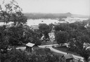
| Description: | View from hill looking down at houses and buildings at an intersection. Beyond are commercial buildings, the river, and the far shoreline. Hills are in the... |
| Date: | |
|---|---|
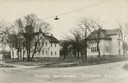
| Description: | View of school buildings across an intersection, with a street light suspended from cables in the foreground. Caption reads: "School Buildings Durand Wis." |
| Date: | 1915 |
|---|---|
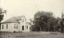
| Description: | View from road of the Pepin Village Hall. The Methodist Church is at the far right. Caption reads: "Pepin, Wis." |
| Date: | 1908 |
|---|---|
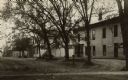
| Description: | View along an unpaved street towards a white building on the right. It appears to house a general store, and signs are on the front of the building. Handwr... |
| Date: | |
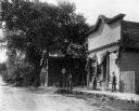
|---|---|
| Description: | Three men and a young girl stand on a wooden sidewalk on the right in front of what appears to be a storefront. A group of four small children stand agains... |

| Date: | 1913 |
|---|---|
| Description: | This 1913 map of Pepin County, Wisconsin, shows the township and range grid, towns, villages, rural routes, railroads, roads, schools, churches, cemeteries... |

| Date: | 1922 |
|---|---|
| Description: | This map of Pepin County, Wisconsin, from the first half of the 20th century shows the township and range grid, towns, villages, railroads, roads, schools,... |

| Date: | 1850 |
|---|---|
| Description: | This series of maps shows townships, ranges, sections, lakes, rivers, and roads. The maps cover areas between Township No. 26 and Township No. 42. |
If you didn't find the material you searched for, our Library Reference Staff can help.
Call our reference desk at 608-264-6535 or email us at: