 Filter: Categories of Wisconsin Historical Images
Filter: Subject of Roads
Filter: County of Ozaukee
Filter: Categories of Wisconsin Historical Images
Filter: Subject of Roads
Filter: County of Ozaukee

| Date: | 1882 |
|---|---|
| Description: | This map of Cedarburg is a bird's-eye map with an inset of Cedarburg Brewery. Relief is shown pictorially and the map includes an index to buildings. |
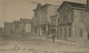
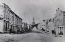
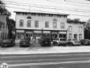
| Date: | 1907 |
|---|---|
| Description: | View across Washington Avenue. A man is standing in the street near the curb. Caption reads: "Cedarburg, Wis., Washington Avenue looking North." |
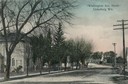
| Date: | 1905 |
|---|---|
| Description: | North view down Washington Avenue. Caption reads: "'Washington Ave., North' Cedarburg Wis." |
| Date: | 1933 |
|---|---|
| Description: | View down dirt road towards the covered bridge over Cedar Creek, south approach. |
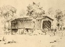
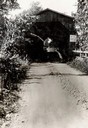
| Date: | 1940 |
|---|---|
| Description: | Drawing of a covered bridge in Cedarburg. |
| Date: | 1940 |
|---|---|
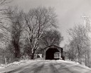
| Description: | Last covered bridge to remain standing in Wisconsin. In the distance an automobile is parked on the side of the road in the shade of a tree. Caption along ... |
| Date: | 1957 |
|---|---|
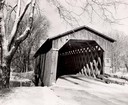
| Description: | Covered bridge over Cedar Creek in Ozaukee County on highway, about one mile north of Cedarburg. The last remaining covered bridge in Wisconsin. Snow is on... |
| Date: | 1957 |
|---|---|
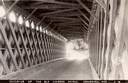
| Description: | View through the covered bridge over Cedar Creek in Ozaukee County on highway, about one mile north of Cedarburg. The last remaining covered bridge in Wisc... |
| Date: | 1957 |
|---|---|
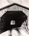
| Description: | Covered bridge over Cedar Creek in Ozaukee County on highway, about one mile north of Cedarburg. The last remaining covered bridge in Wisconsin. Snow is on... |
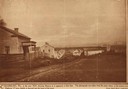
| Date: | 1850 |
|---|---|
| Description: | Main Street in Cedarburg. Includes text which reads: "Cedarburg, Wis., in the year 1850, showing Main Street as it appeared at that time. The photograph wa... |
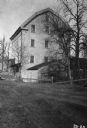
| Date: | 1934 |
|---|---|
| Description: | Exterior of Concordia Mills, once a grain/grist mill. |
| Date: | 1884 |
|---|---|
| Description: | A distant view of St. Mary's Church. Looking north from the corner of Main and Franklin Streets. |
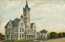
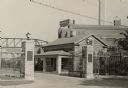
| Date: | 1915 |
|---|---|
| Description: | View across road towards the Ozaukee County Court House. Caption reads: "Court House, Port Washington, Wis." |
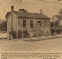
| Date: | 1966 |
|---|---|
| Description: | House on Grand Avenue, built about 1836. "Few people who drive by this house on Port Washington's Grand Avenue daily realize that it is possibly the city's... |
| Date: | 1940 |
|---|---|
| Description: | A view of the Pebble house, also called Edward Dodge House. Built in 1848 and constructed of cobblestone. Stone columns with a gate and fence are in front ... |
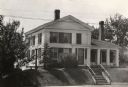
| Date: | 1935 |
|---|---|
| Description: | View of the Blake House (north elevation, front). The house was razed prior to 1952. |
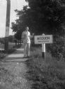
| Date: | |
|---|---|
| Description: | Harold Gauer, wearing a suit and bow tie, and holding an ice cream cone, stands smiling next to a sign on the shoulder of a road that reads "Mequon / Uninc... |
| Date: | 08 16 2002 |
|---|---|
| Description: | "Today we traveled nearly to Lake Michigan, and dined in the small community of Lake Church at the Lake Church Inn, 69 Hwy D. Belgium, WI." |
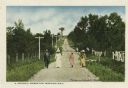
| Date: | |
|---|---|
| Description: | Well-dressed group of three women and one man walking along a dirt road lined with fences and telephone poles. Caption reads: "A Stroll through Donges Bay.... |

| Date: | 1961 |
|---|---|
| Description: | This 1961 map of Ozaukee County, Wisconsin, identifies historic sites and landmarks in the county. Cities and villages, roads, and lakes and streams are al... |
If you didn't find the material you searched for, our Library Reference Staff can help.
Call our reference desk at 608-264-6535 or email us at: