Filter: Categories of Wisconsin Historical Images
Filter: Subject of Roads
Filter: County of Menominee
Filter: Categories of Wisconsin Historical Images
Filter: Subject of Roads
Filter: County of Menominee
| Date: | 1929 |
|---|---|
| Description: | Keshena Indian School, an Indian Government School building. |
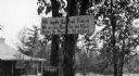
| Date: | |
|---|---|
| Description: | A toll road sign on the Keshena Menominee Reservation for the Highway 55 toll road that goes through the reservation. |
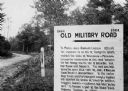
| Date: | 1923 |
|---|---|
| Description: | Old Military Road sign. Sign reads: "1864 — 1924 Old Military Road — In March — 1863 — Abraham Lincoln affixed his signature to an act of Congress which en... |
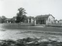
| Date: | 1935 |
|---|---|
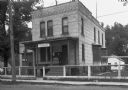
| Description: | U.S. Department of the Indian agency building on the Menominee Indian Reservation. |
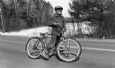
| Date: | 04 1954 |
|---|---|
| Description: | A young Menominee Indian (Charles ?) pauses briefly for a photograph while straddling his bicycle. He is stopped on the road with the snow-covered Wolf Riv... |
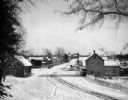
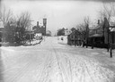
| Date: | 1902 |
|---|---|
| Description: | Elevated winter scene of snow-covered road through Keshena, Wisconsin. There are horse-drawn vehicles and pedestrians, and a church is in the background. |
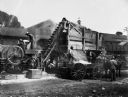
| Date: | 1910 |
|---|---|
| Description: | A crew of men crushing rock for Senator James H. Stout's improved highway. |

| Date: | 09 03 1925 |
|---|---|
| Description: | A deteriorating one and a half-story log structure owned by John Corn. He was a Menomonee tribesman who operated a logger's place of entertainment and supp... |
| Date: | 1974 |
|---|---|
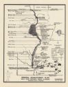
| Description: | This map is a 9 part map detailing various parts of Menominee County, Wisconsin. Page 1 of the map shows federal aid control in the county and was used by ... |

| Date: | 1956 |
|---|---|
| Description: | This map shows reservation boundaries, U.S. township lines, highways, roads, rivers, and lakes. The lower left corner of the map includes a legend of "Conv... |

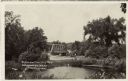
| Date: | |
|---|---|
| Description: | Photographic postcard view across field towards a row of apartment buildings. Caption reads: "At Keshena Falls on Highway #47, Wis." |
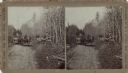
| Date: | |
|---|---|
| Description: | Stereograph of two Menomonee Indian family groups in horse-drawn wagons. One boy is standing next to a wagon and a man is standing on the right holding a g... |
| Date: | |
|---|---|
| Description: | View over water towards a road leading to a bridge. A man is standing next to an automobile on the side of the road. |
If you didn't find the material you searched for, our Library Reference Staff can help.
Call our reference desk at 608-264-6535 or email us at: