 Filter: Categories of Wisconsin Historical Images
Filter: Subject of Roads
Filter: County of Lincoln
Filter: Categories of Wisconsin Historical Images
Filter: Subject of Roads
Filter: County of Lincoln

| Date: | 1921 |
|---|---|
| Description: | Warmly-dressed school children riding on the running boards of Theta Mead's car. There is a large building and probably a flag pole in the background. |

| Date: | 1918 |
|---|---|
| Description: | Theta Mead standing next to her car on a rural dirt road holding a book under her arm. |

| Date: | 1943 |
|---|---|
| Description: | A map that shows the lands for sale by the Tomahawk Land Company of Tomahawk, Wisconsin, in the counties of Langlade, Lincoln, Oneida, and Price. The map s... |
| Date: | 09 05 1895 |
|---|---|
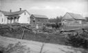
| Description: | View across road of the log buildings and farm home of August Krueger. Two women and three men stand near the fence along the road. One of the men holds a ... |

| Date: | 1915 |
|---|---|
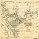
| Description: | This 1915 map of Lincoln County, Wisconsin, shows the township and range grid, towns, cities and villages, lakes and streams, residences, churches, school ... |

| Date: | 1926 |
|---|---|
| Description: | A map of Lincoln County, Wisconsin that shows the township and range grid, towns, cities and villages, lakes and streams, residences, churches, school hous... |
| Date: | 1930 |
|---|---|
| Description: | This map of Tomahawk shows landownership, an original plat of the city, various plat additions, roads, and railroads. The map includes annotations of road ... |
| Date: | 1900 |
|---|---|
| Description: | This map shows areas of Merrill, Corning, Scott, Rock Falls, Russel, Pelisan, Pine River, Ackley, and the Wisconsin River. The left margin of the map inclu... |

| Date: | 1923 |
|---|---|
| Description: | This blue line print map shows townships, landownership, roads, residences, churches, schools, town halls, saw mills, and cheese factories. Includes red ma... |

| Date: | 1902 |
|---|---|
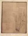
| Description: | A plat map of Lincoln County showing Township 34 North, Range 8 East. |

| Date: | |
|---|---|
| Description: | A photocopy of the T.34N, R.8E portion of a map of Lincoln County. |
| Date: | 1907 |
|---|---|
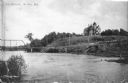
| Description: | View across water towards a large Queen Anne style house sitting on a hill above the Wisconsin River. There is a bridge on the left and a road, now South C... |

| Date: | |
|---|---|
| Description: | Kodak photographic postcard of an aerial view of a lakeside resort with a large, sandy beach. Caption reads: "Phil's Lake Nokomis Resort, Heafford Junction... |

| Date: | 1901 |
|---|---|
| Description: | A Sanborn map of Tomahawk featuring the Bay Mill Company's lumber yard. |

| Date: | 1935 |
|---|---|
| Description: | A narrow, unpaved road passes under a rustic log arbor-like gate which marks the entrance to Bradley Park. The area is heavily wooded with tall but immatur... |

| Date: | 07 1940 |
|---|---|
| Description: | Two well-dressed women are posing next to an automobile parked near the arbor-like gate at the entrance to the Council Grounds State Forest, now the Counci... |

| Date: | 1955 |
|---|---|
| Description: | Text on front reads: "Greetings from Tomahawk, Wisconsin." A aerial view showing the city and Lake Mohawksin on the Wisconsin River. |
If you didn't find the material you searched for, our Library Reference Staff can help.
Call our reference desk at 608-264-6535 or email us at:
