 Filter: Categories of Wisconsin Historical Images
Filter: Subject of Roads
Filter: County of Langlade
Filter: Categories of Wisconsin Historical Images
Filter: Subject of Roads
Filter: County of Langlade
| Date: | |
|---|---|
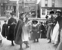
| Description: | A group of girls gathers on a wooden walkway in the central business district. |
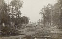
| Date: | 1882 |
|---|---|
| Description: | Caption reads: "5th Ave Antigo Wis Looking West Photo taken in 1882". View down road with felled trees lining both sides. Two men are posing further down t... |
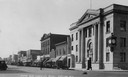
| Date: | 1925 |
|---|---|
| Description: | Caption reads: "5th Ave. Looking West — Antigo, Wis." View across intersection towards the Langlade National Bank on the right corner, which has a clock on... |
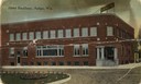
| Date: | 1925 |
|---|---|
| Description: | View toward the hotel on a street corner. A large sign on top of the hotel reads: "Hotel Backbone." Caption reads: "Hotel Backbone, Antigo, Wis." |

| Date: | |
|---|---|
| Description: | Rural dirt road in the town of Antigo. Houses are in the distance. |
| Date: | 1927 |
|---|---|
| Description: | A view looking down an unpaved residential street. Caption reads: "Scene at Phlox Wis." |
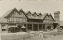
| Date: | |
|---|---|
| Description: | Exterior view of the Muskie Inn. Caption reads: "Muskie Inn, Elcho, Wis." |

| Date: | 1908 |
|---|---|
| Description: | A map of Langlade County, Wisconsin that shows the townships and ranges, towns, cities and villages, wagon roads, churches, schools, lakes, rivers, railroa... |

| Date: | 1908 |
|---|---|
| Description: | Map shows townships and sections, landownership and acreages, rural routes, roads, railroads, creameries, churches, schools, and town halls. Sections appea... |

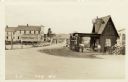
| Date: | 1909 |
|---|---|
| Description: | Street view showing houses, side yards and residents. |

| Date: | 1950 |
|---|---|
| Description: | Aerial view of town, showing all of Lake Metonga in the background. Caption reads: "Greetings from Crandon, Wisconsin." |

| Date: | 1911 |
|---|---|
| Description: | View of an overturned delivery wagon near M. Krachmer's camp, five miles north of Antigo. Caption reads: "A Bad Spill By M. Krachner's." |

| Date: | 1960 |
|---|---|
| Description: | This pictorial map shows recreation activities, rivers, lakes, and the history of the area. The map covers Langlade County and parts of adjacent counties. ... |

| Date: | 1966 |
|---|---|
| Description: | This map shows trails, roads, creeks, alleged location of George Gardner's trading post, Boulder and Mud Lakes, and a portion of the Wolf River. The map al... |

| Date: | 1907 |
|---|---|
| Description: | View looking down center of unpaved main street. The street is lined with dwellings with fenced-in yards. Caption reads: "Elton, Wis." |
| Date: | |
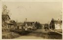
|---|---|
| Description: | Photographic postcard view of the road through a small settlement. A dwelling and a service station are on the right. A general store on the left is on the... |
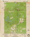
| Date: | 1973 |
|---|---|
| Description: | This standard U.S.G.S. topographic map was annotated by civil engineer and railroad historian James P. Kaysen to show the location of existing and defunct ... |
If you didn't find the material you searched for, our Library Reference Staff can help.
Call our reference desk at 608-264-6535 or email us at: