Filter: Categories of Wisconsin Historical Images
Filter: Subject of Roads
Filter: County of Kenosha
Filter: Categories of Wisconsin Historical Images
Filter: Subject of Roads
Filter: County of Kenosha
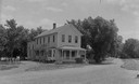
| Date: | 1910 |
|---|---|
| Description: | Lamb's Hotel on a dirt road. The hotel is also called Bewersdorf's Hotel. |
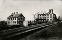
| Date: | 1880 |
|---|---|
| Description: | The Kenosha water cure on the corner of N. Main and Grand Avenue. It was built in the 1840's for educational and religious purposes. It burned down in 1900... |
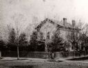
| Date: | 1860 |
|---|---|
| Description: | The home of I.G. Merrill on the corner of Ann Street (now called Sheridan Road) and Prairie Avenue. A person is standing in front of the fence at the corne... |

| Date: | 1879 |
|---|---|
| Description: | The home of I.G. Merrill, located on the corner of Ann Street (now called Sheridan Road) and Prairie Avenue, in the winter. |
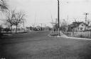
| Date: | 11 17 1937 |
|---|---|
| Description: | Looking northeast on Sheridan Road (State Highway 42) at Sheridan Road Grade Crossing. |

| Date: | |
|---|---|
| Description: | Elevated view of the factory. Caption reads: "Plant of the United Refrigerator and Ice Machine Company, Kenosha, Wis. December 1st, 1912." |
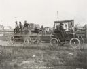
| Date: | 1901 |
|---|---|
| Description: | Thomas B. Jeffery's first Rambler automobile during a test for strength in Kenosha, Wisconsin. |
| Date: | |
|---|---|
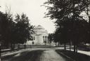
| Description: | Exterior view from tree-lined cobblestone street of the Gilbert M. Simmons Public Library. The library opened in 1900 and was funded with a gift of $150,00... |

| Date: | |
|---|---|
| Description: | Exterior view from tree-lined cobblestone street of the Gilbert M. Simmons Public Library. The library opened in 1900 and was funded with a gift of $150,00... |

| Date: | 1946 |
|---|---|
| Description: | International truck utilized by K*A*T Corporation for multi-automobile hauling. The truck is parked on a road with a river in the background. |

| Date: | 1946 |
|---|---|
| Description: | A man sits behind the steering wheel of an International truck utilized by K*A*T Corporation for multi-automobile hauling. |

| Date: | 1946 |
|---|---|
| Description: | Man driving International truck utilized by K*A*T Corporation for multi-automobile hauling. |

| Date: | 1946 |
|---|---|
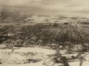
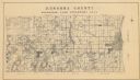
| Description: | A map showing the roads, railroads, towns, cities and villages, streams and lakes, airports, schools, churches, cemeteries, and golf courses in Kenosha Cou... |

| Date: | 1892 |
|---|---|
| Description: | This map shows the dams and locks of the Fox River between Neenah, in Winnebago County, Wisconsin, and Kaukauna, in Outagamie County. The cities and villag... |

| Date: | 1973 |
|---|---|
| Description: | Map shows sections, trails, roads, and locations of ancient burial grounds, hills, groves, and settlers. Printed in brown ink. |

| Date: | 1861 |
|---|---|
| Description: | Depths shown by soundings. Shows township and sections, landownership and acreages, roads, railroads, and buildings. "Entered according to Act of Congress ... |

| Date: | 1910 |
|---|---|
| Description: | Map shows routes, post offices, churches, schools, houses, and roads on the rural delivery service route in blue lines. An explanation key appears on the l... |
| Date: | 1934 |
|---|---|
| Description: | A land inventory map of Kenosha County. The top left features a legend of "Land Cover" and "Roads and Other Improvements". Lake Michigan is labelled to the... |
If you didn't find the material you searched for, our Library Reference Staff can help.
Call our reference desk at 608-264-6535 or email us at: