 Filter: Categories of Wisconsin Historical Images
Filter: Subject of Roads
Filter: County of Iron
Filter: Categories of Wisconsin Historical Images
Filter: Subject of Roads
Filter: County of Iron

| Date: | 1886 |
|---|---|
| Description: | Bird's-eye map of Hurley with insets Mining at the Colby, Hurley in 1885, and North Front of Silver Street. |
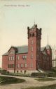
| Date: | 1905 |
|---|---|
| Description: | View across road toward the court house. Caption reads: "Court House, Hurley, Wis." |
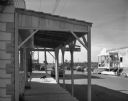
| Date: | 09 18 1961 |
|---|---|
| Description: | Main street of the town, shown during reconstruction for use as a motion picture set. |
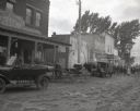
| Date: | 09 18 1961 |
|---|---|
| Description: | View of a downtown area reconstructed for a movie location set. Several contemporary automobiles are seen in the background. Men are working on on two diff... |
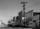
| Date: | 10 03 1961 |
|---|---|
| Description: | View of a downtown street, altered by 20th Century Fox motion picture studio for scenes in the movie "Young Man." For filming, local people dressed the par... |
| Date: | 1938 |
|---|---|
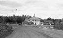
| Description: | View down road of an automobile parked outside the two-story Tower Tea Room, Rest Lake. The one-story building on the right has a sign that says "Crank Cas... |
| Date: | 1938 |
|---|---|
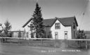
| Description: | Woman standing outside of the two-story Post Office building in Manitowish. There is a road, fence and pine trees in the foreground. |
| Date: | 1932 |
|---|---|
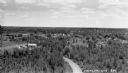
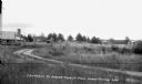
| Description: | Elevated view overlooking Mercer. Roads, trees and buildings are visible. |
| Date: | 1933 |
|---|---|
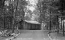
| Description: | Road lined with stones leading up to the one-story Holst's Log Cabin in the woods. |
| Date: | 1931 |
|---|---|
| Description: | View of the road and entrance to Mercer Tourist Park on Grand Portage Lake showing the fences, road and buildings. The larger building on the left has a st... |

| Date: | 1896 |
|---|---|
| Description: | A map of Iron County, Wisconsin, shows vacant Wisconsin Central Rail Road lands, settlers houses, land sold by Wisconsin Central R.R., schools, churches, s... |

| Date: | 1898 |
|---|---|
| Description: | A map of Iron County, Wisconsin, shows vacant Wisconsin Central Rail Road lands, settlers houses, land sold by Wisconsin Central R.R., schools, churches, s... |

| Date: | 1922 |
|---|---|
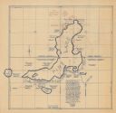
| Description: | A map of Iron County, Wisconsin, shows sections and the towns of Upson, Hurley, Hamilton, Saxon, and Mercer, lakes and streams, villages, railroads, roads ... |

| Date: | 1932 |
|---|---|
| Description: | A map of Iron County, Wisconsin, shows towns and sections, lakes and streams, villages, railroads, roads, and La Point and Lac Du Flambeau Indian reservati... |

| Date: | |
|---|---|
| Description: | A map that shows the Wisconsin Central Railway land grant lands for sale by the Soo Line, the Chicago, Milwaukee, and St. Paul Railway. Town sections, lak... |

| Date: | |
|---|---|
| Description: | A map of Iron County, Wisconsin, shows color-coded townships, sections, lakes and streams, villages, railroads, roads, tourist camps, and La Pointe and Lac... |
| Date: | 1935 |
|---|---|
| Description: | This map shows property owners, government lots, and roads around Pine Lake in Rusk and Chippewa Counties. Also shows Silver and McDonald Lakes. "This map ... |

| Date: | 1934 |
|---|---|
| Description: | This 1934 zoning map of Iron County, Wisconsin, shows the township and range grid, towns, sections, roads, and lakes and streams. Forestry and recreation d... |

| Date: | 02 1898 |
|---|---|
| Description: | Sanborn map of Hurley featuring the Montreal Mining Company. |

| Date: | 1941 |
|---|---|
| Description: | This is map one of three maps that show trails, roads and fire lanes, utilities, resorts, submerged lakes, vegetation, flowage right lands, and timber righ... |
If you didn't find the material you searched for, our Library Reference Staff can help.
Call our reference desk at 608-264-6535 or email us at: