Filter: Categories of Wisconsin Historical Images
Filter: Subject of Roads
Filter: County of Green Lake
Filter: Categories of Wisconsin Historical Images
Filter: Subject of Roads
Filter: County of Green Lake

| Date: | 1892 |
|---|---|
| Description: | Bird's-eye map of Princeton, with an inset of the Residence of F.T. Yahr. Fox River loops to left of center, with one bridge; thirty-six businesses, reside... |
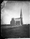
| Date: | 1869 |
|---|---|
| Description: | View down road towards the exterior of a large brick church with a stone foundation, belfry and steeple. A group of people stand in front of the white boar... |
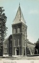
| Date: | 1900 |
|---|---|
| Description: | Front view of a Baptist church. Caption reads: "Baptist Church, Berlin, Wis." |

| Date: | 1920 |
|---|---|
| Description: | Exterior view across road towards the Congregational Church. |
| Date: | 1925 |
|---|---|
| Description: | Exterior of the White House Inn, a three-story wooden structure with a two-story wing in the rear. A road sign for Highway 23 is in the foreground on the c... |
| Date: | 07 20 1988 |
|---|---|
| Description: | Lincoln Drive Bridge in the Town of Berlin, Marathon County. The road in the foreground is not paved, and to the left is a red barn. |

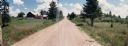
| Date: | 11 05 1986 |
|---|---|
| Description: | Green Lake County Highway M meandering toward a red barn in the distance on a November day, an archtypal Wisconsin landscape. |
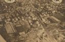
| Date: | 1935 |
|---|---|
| Description: | Aerial view of town. Caption reads: "No. 25. Markesan, in Green Lake county, on state trunk highway 103, is a town of homes. Its inhabitants number 1,000." |

| Date: | 1905 |
|---|---|
| Description: | View down unpaved road towards a drawbridge in Princeton. There is a hotel on the right. Caption reads: "Draw Bridge at Princeton, Wis." |
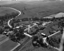
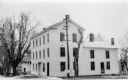
| Date: | 09 10 1947 |
|---|---|
| Description: | Aerial view of the River View Cannery. |
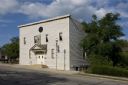
| Date: | 2009 |
|---|---|
| Description: | Exterior view of Thrasher Opera House from across street. |
| Date: | |
|---|---|
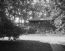
| Description: | View of Dering's Resort, located in a wooded area. In the foreground is a road, and on the other side is a resort cabin with a small garden and bird bath. |

| Date: | |
|---|---|
| Description: | View of a greenhouse. An ivy-covered building and a watch tower are visible to the left of the greenhouse. An automobile is parked on a street, separated f... |

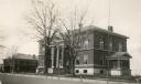
| Date: | |
|---|---|
| Description: | View down Capron Street, a dirt road in a residential area. There is a clocktower on a building in the distance. |
| Date: | 1898 |
|---|---|
| Description: | A hydrographic map of Green Lake, Geneva, Wisconsin, and includes 5 cross sections of the depths at various points as well as along a line running the leng... |

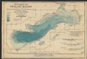
| Date: | 1937 |
|---|---|
| Description: | A pictorial, hydrographic map shows sailing courses, historical and contemporary coastal attractions, roads, and the contour depths of Green Lake, Wisconsi... |
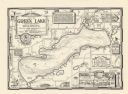
| Date: | 1970 |
|---|---|
| Description: | A pictorial map shows roads, parks, points of interest, keys to the property owners' association directory, and the contour depths of Green Lake, Wisconsin... |

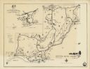
| Date: | 1896 |
|---|---|
| Description: | A map of Green Lake County, Wisconsin, shows township divisions, villages and post offices, railroads, roads, lakes and streams, schools, and churches. |
| Date: | |
|---|---|
| Description: | A map of the Northern Baptist Assembly estate on the shore of Green Lake, Green Lake County, Wisconsin shows roads, buildings, and private homes. An inset ... |
If you didn't find the material you searched for, our Library Reference Staff can help.
Call our reference desk at 608-264-6535 or email us at: