 Filter: Categories of Wisconsin Historical Images
Filter: Subject of Roads
Filter: County of Grant
Filter: Categories of Wisconsin Historical Images
Filter: Subject of Roads
Filter: County of Grant

| Date: | 1850 |
|---|---|
| Description: | This map of Cassville shows plat of the town, roads, landings and public wharfs and the Mississippi River. |

| Date: | 10 18 1962 |
|---|---|
| Description: | Seven men are posing outdoors for a snapshot: from right to left: Mink, Gustaveson, Nelson, Bently, Williams, Carpenter, Harrington. |

| Date: | 10 18 1962 |
|---|---|
| Description: | Seven men posing outdoors in front of automobiles. Left to right: Carpenter, Harrington, Williams, Bently?, Nelson, Gustaveson, Mink. |
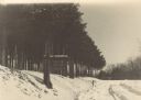
| Date: | 1935 |
|---|---|
| Description: | View down snowy road through a forest improvement area in Wyalusing State Park. There is a truck in the background, and a sign on the left side of the road... |

| Date: | 03 31 2012 |
|---|---|
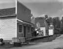
| Description: | View from road of Brown School, a brick school building near Fennimore. |
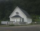
| Date: | 07 27 2012 |
|---|---|
| Description: | Exterior view of the Methodist Evangelical Church, with stairs and a ramp at the front of the building. |

| Date: | |
|---|---|
| Description: | A vintage view and a modern view of the Methodist Evangelical Church, presented as a pair. |
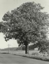
| Date: | 1955 |
|---|---|
| Description: | A very large white oak tree standing along County Trunk Highway S dwarfs a utility pole nearby. There is a barn across a field in the far background. The t... |
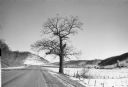
| Date: | 1982 |
|---|---|
| Description: | A large white oak in a snowy landscape along County Trunk Highway S. The tree is asymmetrical, missing portions of several major limbs. There is a silo an... |

| Date: | 1979 |
|---|---|
| Description: | A mature sycamore tree standing in front of farm buildings and a silo. There is a mailbox and fire number sign at the edge of a road in the foreground. The... |

| Date: | 1967 |
|---|---|
| Description: | A horse-drawn carriage carrying visitors is coming through a covered bridge at Stonefield Village. |

| Date: | 1854 |
|---|---|
| Description: | Pleasant Ridge Log Church. Pleasant Ridge farmers built a United Brethren Church in 1884. |

| Date: | 1918 |
|---|---|
| Description: | Elevated view of Slabtown/Flora Fountain. The church in the lower right was built by the Latter Day Saints and later moved to Lancaster. |

| Date: | 1908 |
|---|---|
| Description: | View of the entrance gate and stone columns for a road to a cemetery. Caption reads: "Hillside Cemetery, Lancaster, Wis." |
| Date: | 1970 |
|---|---|
| Description: | A crowd is standing on the boardwalk in front of a building at Stonefield Village, a Wisconsin Historical Society site. |
| Date: | 1961 |
|---|---|
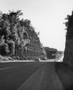
| Description: | Two automobiles driving on a highway cutting between two halves of a rock outcropping. The rock was blasted to build the road. |

| Date: | 11 03 1903 |
|---|---|
| Description: | A drawing of a group of burial mounds in Linden Valley. Text on back reads: "These mounds lie at the narrow mouth of Linden Valley on the east side of the ... |
If you didn't find the material you searched for, our Library Reference Staff can help.
Call our reference desk at 608-264-6535 or email us at: