 Filter: Categories of Wisconsin Historical Images
Filter: Subject of Roads
Filter: County of Grant
Filter: Categories of Wisconsin Historical Images
Filter: Subject of Roads
Filter: County of Grant

| Date: | |
|---|---|
| Description: | View down Denniston Avenue. On the left side behind a long row of fences along the sidewalk are dwellings and a church. On the right side dwellings are alo... |

| Date: | 1920 |
|---|---|
| Description: | A map of the Nelson-Dewey State Park at the confluence of the Mississippi and Wisconsin rivers, showing the topographical features of the area, as well as ... |

| Date: | 1920 |
|---|---|
| Description: | This 1920 map actually depicts present-day Wyalusing State Park at the confluence of the Mississippi and Wisconsin rivers in the Town of Wyalusing, Grant C... |

| Date: | 1842 |
|---|---|
| Description: | Relief shown by hachures. Shows furnaces, saw mills, houses, roads, grist mills, entries, reservations, and diggings. "Compiled by order of the Board of C... |

| Date: | 1857 |
|---|---|
| Description: | Relief shown by hachures. "Lith. of Ed. Mendel, Chicago." Shows townships and sections, rivers, roads, railroads, houses, flour mills, saw mills, furnaces... |
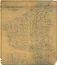
| Date: | 1910 |
|---|---|
| Description: | Shows roads, railroads, post offices, schools, houses, churches, and routes. Includes distant chart and explanation. "Price 35 cents"--Upper left margin. "... |

| Date: | 1928 |
|---|---|
| Description: | Shows different types of roads, railroads, schools, churches, farmsteads, cheese factories, mine shafts, old surface workings, streams, old sulphur pits, a... |
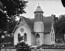
| Date: | |
|---|---|
| Description: | View of the exterior of the Congregational Church, with arched windows and belfry. In the arched window above the doorway it reads: "1891 Cong'l Church." I... |

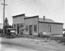
| Date: | 1922 |
|---|---|
| Description: | View across unpaved road of the Preston Business District. Three men and a young child stand in front of what may to be a general store, with large show wi... |
| Date: | 1925 |
|---|---|
| Description: | View across road towards Chaney's Cash General Store. Behind trees on the left is a house and windmill. Laundry is drying behind the store on the right. A ... |

| Date: | 1925 |
|---|---|
| Description: | View across road towards the parochial school, which is a two-story brick building with a cross on the steeple. Arched windows are above the entrance. Tree... |
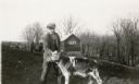
| Date: | 1931 |
|---|---|
| Description: | Claire Alexander posing with a young calf in a pasture near a wooded ravine at his father's farm. There is a manure spreader and shed in the background. |

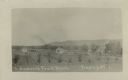
| Date: | 1908 |
|---|---|
| Description: | Elevated photographic postcard view of town showing homes and businesses. A windmill is in the foreground. The school is on the far edge of town on the lef... |
| Date: | |
|---|---|
| Description: | Photographic postcard view of a slightly elevated view of the fruit ranch. Rows of crops in the foreground are bordered by a row of trees. Three dwellings ... |
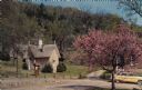
| Date: | |
|---|---|
| Description: | Color postcard featuring the redbud tree at Stonefield Village. The smokehouse is on the left. An automobile is parked in the drive. |
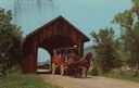
| Date: | |
|---|---|
| Description: | Color postcard of a covered bridge at Stonefield Village with a horse bus passing through it. |
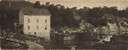
| Date: | 1908 |
|---|---|
| Description: | View of the Rundolph Mill and dam near Muscoda. A man stands near the far side of the bridge on the left. The banks of the river are rocky cliffs, and a st... |

| Date: | 1938 |
|---|---|
| Description: | Exterior view from road of the Gillette photography studio. Lorin is standing and posing next to the sign. An upside down sign is resting in the tall grass... |
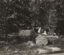
| Date: | 1920 |
|---|---|
| Description: | View towards hillside with an outcropping of large talus rocks surrounded by trees near Castle Rock village. In the foreground is what appears to be a dirt... |

| Date: | 1971 |
|---|---|
| Description: | This map of Nelson Dewey State Park shows the park layout, points of interest, facilities, campgrounds, roads, railroads, and the Mississippi River. Relief... |
If you didn't find the material you searched for, our Library Reference Staff can help.
Call our reference desk at 608-264-6535 or email us at: